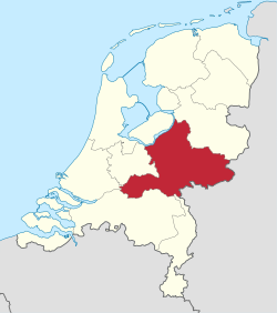
Gelderland
| Gelderland | |||
|---|---|---|---|
| Province of the Netherlands | |||
|
|||
| Anthem: "Ons Gelderland" "Our Gelderland" |
|||
 Location of Gelderland in the Netherlands |
|||
| Coordinates: 52°04′N 5°57′E / 52.06°N 5.95°ECoordinates: 52°04′N 5°57′E / 52.06°N 5.95°E | |||
| Country | Netherlands | ||
| Capital | Arnhem | ||
| Largest city | Nijmegen | ||
| Government | |||
| • King's Commissioner | Clemens Cornielje (VVD) | ||
| Area | |||
| • Land | 4,971.76 km2 (1,919.61 sq mi) | ||
| • Water | 164.75 km2 (63.61 sq mi) | ||
| Area rank | 1 | ||
| Population (1 January 2015) | |||
| • Land | 2,026,578 | ||
| • Rank | 4th | ||
| • Density | 410/km2 (1,100/sq mi) | ||
| • Density rank | 6th | ||
| ISO 3166 code | NL-GE | ||
| Religion (1999) | 31% Protestant, 29% Catholic | ||
| Website | www.gelderland.nl | ||
Gelderland (Dutch pronunciation: [ˈɣɛldərˌlɑnt], also Guelders in English) is a province of the Netherlands, located in the central eastern part of the country. With a land area of nearly 5,000 km2, it is the largest province of the Netherlands and shares borders with six other provinces and Germany.
The capital is Arnhem. However, both Nijmegen and Apeldoorn are larger cities, Nijmegen being the largest with nearly 170,000 inhabitants. Other major regional centres in Gelderland are Ede, Doetinchem, Zutphen, Tiel, Wageningen, Zevenaar, Winterswijk and Harderwijk.
Gelderland had a population of just over two million in 2015.
According to the Wichard saga, the city was named by the Lords of Pont who fought and killed a dragon in 878 AD. They named the town they founded after the death rattle of the dragon: "Gelre!"
Historically, the province dates from states of the Holy Roman Empire and takes its name from the nearby German city of Geldern.
The County of Guelders arose out of the Frankish pagus Hamaland in the 11th century around castles near Roermond and the town of Geldern. The counts of Gelre acquired the Betuwe and Veluwe regions and, through marriage, the County of Zutphen. Thus the counts of Guelders laid the foundation for a territorial power that, through control of the Rhine, Waal, Meuse and IJssel rivers, was to play an important role in the later Middle Ages. The geographical position of their territory dictated the external policy of the counts during the following centuries; they were committed to the interests of the Holy Roman Empire and to expansion south and west.
...
Wikipedia


