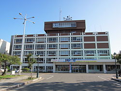
Yurihonjō, Akita
|
Yurihonjō 由利本荘市 |
|||
|---|---|---|---|
| City | |||

Yurihonjō City Hall
|
|||
|
|||
 Location of Yurihonjō in Akita Prefecture |
|||
| Coordinates: 39°23′9.1″N 140°2′55.8″E / 39.385861°N 140.048833°ECoordinates: 39°23′9.1″N 140°2′55.8″E / 39.385861°N 140.048833°E | |||
| Country | Japan | ||
| Region | Tōhoku | ||
| Prefecture | Akita Prefecture | ||
| Area | |||
| • Total | 1,209.60 km2 (467.03 sq mi) | ||
| Population (May 2015) | |||
| • Total | 79,935 | ||
| • Density | 66.1/km2 (171/sq mi) | ||
| Time zone | Japan Standard Time (UTC+9) | ||
| - Tree | Zelkova serrata | ||
| - Flower | Sakura | ||
| Phone number | 0184-24-3321 | ||
| Address | 17 Ozaki Yurihonjō-shi, Akita-ken 015-8501 | ||
| Website | Official website | ||
Yurihonjō (由利本荘市 Yurihonjō-shi?) is a city located in Akita Prefecture, in the northern Tohoku region of Japan.
As of May 2015, the city has an estimated population of 79,935 and a population density of 66.1 persons per km². The total area was 1,209.60 square kilometres (467.03 sq mi).
Yurihonjō is located in southwest corner of Akita Prefecture, bordered by the Sea of Japan to the west, and by Yamagata Prefecture to the south. It is the largest municipality in Akita Prefecture in terms of area. Part of the city is within the borders of the Chōkai Quasi-National Park.
Yurihonjō has a Humid continental climate (Köppen climate classification Cfa) with large seasonal temperature differences, with warm to hot (and often humid) summers and cold (sometimes severely cold) winters. Precipitation is significant throughout the year, but is heaviest from August to October.
The area of present-day Yurihonjō was part of ancient Dewa Province, dominated by the Mogami clan during the Sengoku period. Under the Tokugawa shogunate, part of the area came under the control of Honjō Domain, Kameda Domain and Yashima Domain, with a very small portion under direct rule by the shogunate (tenryō).
...
Wikipedia


