Yucatán (peninsula)

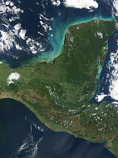
Satellite image of the Yucatán Peninsula
|
|
 |
|
| Geography | |
|---|---|
| Location | North America |
| Coordinates | 18°50′42″N 89°07′32″W / 18.84500°N 89.12556°WCoordinates: 18°50′42″N 89°07′32″W / 18.84500°N 89.12556°W |
| Adjacent bodies of water | Gulf of Mexico |
The Yucatán Peninsula (Spanish: Península de Yucatán), in southeastern Mexico, separates the Caribbean Sea from the Gulf of Mexico, with the northern coastline on the Yucatán Channel. The peninsula lies east of the Isthmus of Tehuantepec, a northwestern geographic partition separating the region of Central America from the rest of North America.
The proper derivation of the word Yucatán is widely debated. Hernán Cortés, in the first of his letters to Charles V, the Holy Roman Emperor, claimed that the name Yucatán comes from a misunderstanding. In this telling, the first Spanish explorers asked what the area was called and the response they received, "Yucatan," was a Yucatec Maya word meaning "I don't understand what you're saying." Others claim that the source of the name is the Nahuatl (Aztec) word Yocatlān, "place of richness."
The Yucatán Peninsula is the site of the Chicxulub crater impact, which was created 66 million years by an asteroid of about 10 to 15 kilometres (6 to 9 miles) in diameter.
The Yucatán Peninsula comprises a significant proportion of the ancient Maya Lowlands (although the Maya culture extended south of the Yucatán Peninsula, through present Guatemala and into Honduras and highland Chiapas). There are many Maya archaeological sites throughout the peninsula; some of the better-known are Chichen Itza, Tulum and Uxmal.Indigenous Maya and Mestizos of partial Maya descent make up a sizable portion of the region's population, and Mayan languages are widely spoken there.
...
Wikipedia
