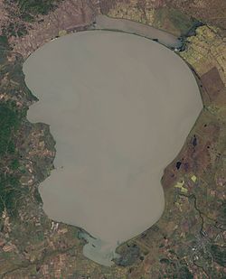
Xingkai Lake
| Lake Khanka Lake Xingkai о́зеро Ха́нка 兴凯湖 |
|
|---|---|

Landsat 7 image (2001)
|
|
| Location | Primorsky Krai, Russia / Heilongjiang, China |
| Coordinates | 45°0′N 132°25′E / 45.000°N 132.417°ECoordinates: 45°0′N 132°25′E / 45.000°N 132.417°E |
| Primary outflows | Songacha River |
| Basin countries | People's Republic of China, Russia |
| Max. length | 90 km (56 mi) |
| Max. width | 45 km (28 mi) |
| Surface area | 4,070 km2 (1,570 sq mi) |
| Average depth | 4.5 m (15 ft) |
| Max. depth | 10.6 m (35 ft) |
| Water volume | 18.3 km3 (4.4 cu mi) |
| Residence time | 9.9 yrs |
| Shore length1 | 308 km (191 mi) |
| Surface elevation | 68 m (223 ft) - 70 m (230 ft) |
| Frozen | December–April |
| Designated | October 12, 1974 |
| 1 Shore length is not a well-defined measure. | |
Lake Khanka (Russian: о́зеро Ха́нка) or Lake Xingkai (simplified Chinese: 兴凯湖; traditional Chinese: 興凱湖; pinyin: Xīngkǎi Hú), is a freshwater lake located on the border between Primorsky Krai, Russia and Heilongjiang province, Northeast China (at 45°0′N 132°25′E / 45.000°N 132.417°E).
The lake's drainage basin covers an area of 16,890 square kilometres (6,520 sq mi), of which 97% is in Russian territory. It has 4,000 to 4,400 km2 (1,500 to 1,700 sq mi) of water surface area. It is fed by 23 rivers (8 in China and 15 in Russia), but the only outflow of the lake is the Songacha River.
The lake's average depth is 4.5 metres (15 ft), while its maximum depth is 10.6 m (35 ft). Its average volume is 18.3 cubic kilometres (4.4 cu mi), though it can fill up to 22.6 km3 (5.4 cu mi). The lake belongs to the Ussuri River System, which is part of Amur River System.
The maximum monthly mean temperature is 20 °C (68 °F) in July, while the minimum monthly mean temperature is −21 °C (−6 °F) in January. Rainfall mainly occurs in summer, with average annual precipitation of 500-650 mm annually.
...
Wikipedia
