Wortham, Texas
| Wortham, Texas | |
|---|---|
| Town | |
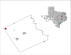
 Location of Wortham, Texas |
|
 |
|
| Coordinates: 31°47′18″N 96°27′44″W / 31.78833°N 96.46222°WCoordinates: 31°47′18″N 96°27′44″W / 31.78833°N 96.46222°W | |
| Country | United States |
| State | Texas |
| County | Freestone |
| Area | |
| • Total | 2.0 sq mi (5.1 km2) |
| • Land | 2.0 sq mi (5.1 km2) |
| • Water | 0.0 sq mi (0.0 km2) |
| Elevation | 476 ft (145 m) |
| Population (2010) | |
| • Total | 1,073 |
| • Density | 540/sq mi (208.5/km2) |
| Time zone | Central (CST) (UTC-6) |
| • Summer (DST) | CDT (UTC-5) |
| ZIP code | 76693 |
| Area code(s) | 254 |
| FIPS code | 48-80296 |
| GNIS feature ID | 1350596 |
Wortham is a town in Freestone County, Texas, United States. The population was 1,073 at the 2010 census.
Wortham is located in the northwest corner of Freestone County at 31°47′18″N 96°27′44″W / 31.78833°N 96.46222°W (31.788472, -96.462209).Texas State Highway 14 runs through town as Third Street, leading north 10 miles (16 km) to Richland and Interstate 45, and south 8 miles (13 km) to Mexia. Fairfield, the Freestone County seat, is 18 miles (29 km) to the southeast.
According to the United States Census Bureau, the town has a total area of 2.0 square miles (5.1 km2), all of it land. Wortham lies near the highest point between Dallas and Houston, the nearby Tehuacana Hills.
Wortham is situated on a grant given in 1834 by Mexico to Robert B. Longbotham (born December 29, 1797), an immigrant from England who settled there in 1839. In 1871, when the Houston and Texas Central Railway was planned through the area, Longbotham sold the right of way for five dollars. A townsite was purchased from Longbotham by a group of investors, who platted a town named "Tehuacana". When a post office was established in November 1871, however, the name was changed to "Long Bottom", a corruption of the original owner's name. In 1874 the settlement was renamed "Wortham" in honor of Col. Rice Wortham, a merchant who had been instrumental in convincing the railroad to build through the area.
...
Wikipedia
