Mexia, Texas
| Mexia, Texas | |
|---|---|
| City | |
| Motto: A great place to live, no matter how you pronounce it | |
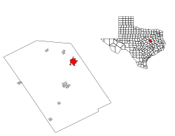
 Location of Mexia, Texas |
|
 |
|
| Coordinates: 31°40′54″N 96°28′52″W / 31.68167°N 96.48111°WCoordinates: 31°40′54″N 96°28′52″W / 31.68167°N 96.48111°W | |
| Country | United States |
| State | Texas |
| County | Limestone |
| Area | |
| • Total | 5.2 sq mi (13.3 km2) |
| • Land | 5.2 sq mi (13.3 km2) |
| • Water | 0.0 sq mi (0.0 km2) |
| Elevation | 522 ft (159 m) |
| Population (2010) | |
| • Total | 7,459 |
| • Density | 1,434.4/sq mi (560.8/km2) |
| Time zone | Central (CST) (UTC-6) |
| • Summer (DST) | CDT (UTC-5) |
| ZIP code | 76667 |
| Area code(s) | 254 |
| FIPS code | 48-47916 |
| GNIS feature ID | 1362673 |
Mexia (/məˈheɪ.ə/ mə-HAY-ə or /məˈhɛər/ mə-HAIR) is a city in Limestone County, Texas, United States. The population was 7,459 at the 2010 census.
The city's motto, based on the fact that outsiders tend to mispronounce the name [ˈmɛksiə], is "A great place, no matter how you pronounce it."
Named after General José Antonio Mexía, a Hispanic hero for the Republic of Texas Army during the Texas Revolution, the town was founded near his estate. Nearby attractions include Fort Parker Historical recreation, the Confederate Reunion grounds, and Mexia State Supported Living Center (formerly Mexia State School), which began as a prisoner of war camp for members of Field Marshal Erwin Rommel's Afrika Korps during World War II.
...
Wikipedia
