Woodland Township, New Jersey
| Woodland Township, New Jersey | |
|---|---|
| Township | |
| Township of Woodland | |

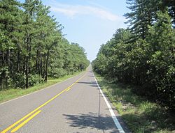
Savoy Boulevard through the Pine Barrens in Woodland Township
|
|
 Woodland Township highlighted in Burlington County. Inset map: Burlington County highlighted in the State of New Jersey. |
|
 Census Bureau map of Woodland Township, New Jersey |
|
| Coordinates: 39°50′29″N 74°31′04″W / 39.841289°N 74.51774°WCoordinates: 39°50′29″N 74°31′04″W / 39.841289°N 74.51774°W | |
| Country |
|
| State |
|
| County | Burlington |
| Incorporated | March 7, 1866 |
| Government | |
| • Type | Township |
| • Body | Township Committee |
| • Mayor | Matthew A. Henrich (R, term ends December 31, 2016) |
| • Administrator / Clerk | Maryalice Brown |
| Area | |
| • Total | 96.385 sq mi (249.638 km2) |
| • Land | 94.558 sq mi (244.905 km2) |
| • Water | 1.827 sq mi (4.733 km2) 1.90% |
| Area rank | 6th of 566 in state 2nd of 40 in county |
| Elevation | 118 ft (36 m) |
| Population (2010 Census) | |
| • Total | 1,788 |
| • Estimate (2015) | 1,793 |
| • Rank | 499th of 566 in state 35th of 40 in county |
| • Density | 18.9/sq mi (7.3/km2) |
| • Density rank | 563rd of 566 in state 39th of 40 in county |
| Time zone | Eastern (EST) (UTC-5) |
| • Summer (DST) | Eastern (EDT) (UTC-4) |
| ZIP code | 08019 - Chatsworth |
| Area code(s) | 609 |
| FIPS code | 3400582420 |
| GNIS feature ID | 0882080 |
| Website | www |
Woodland Township is a township in Burlington County, New Jersey, United States. As of the 2010 United States Census, the township's population was 1,788 reflecting an increase of 618 (+52.8%) from the 1,170 counted in the 2000 Census, which had in turn declined by 893 (-43.3%) from the 2,063 counted in the 1990 Census.
Woodland was incorporated as a township by an act of the New Jersey Legislature on March 7, 1866, from portions of Pemberton Township, Shamong Township, Southampton Township and Washington Township. Portions of the township were taken to form Tabernacle Township on March 22, 1901.
According to the United States Census Bureau, the township had a total area of 96.385 square miles (249.638 km2), including 94.558 square miles (244.905 km2) of land and 1.827 square miles (4.733 km2) of water (1.90%).
The township borders Bass River Township, Pemberton Township, Southampton Township, Tabernacle Township, Washington Township in Burlington County; and Barnegat Township, Lacey Township, Little Egg Harbor Township and Manchester Township in Ocean County.
...
Wikipedia
