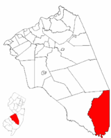
Bass River Township, New Jersey
| Bass River Township, New Jersey | |
|---|---|
| Township | |
| Township of Bass River | |
| Motto: "A Clean Community" | |
 Bass River Township highlighted in Burlington County. Inset map: Burlington County highlighted in the State of New Jersey. |
|
 Census Bureau map of Bass River Township, New Jersey |
|
| Coordinates: 39°39′30″N 74°26′53″W / 39.658443°N 74.448127°WCoordinates: 39°39′30″N 74°26′53″W / 39.658443°N 74.448127°W | |
| Country | |
| State |
|
| County | Burlington |
| Incorporated | March 30, 1864 |
| Named for | Jeremiah Basse |
| Government | |
| • Type | Walsh Act |
| • Body | Board of Commissioners |
| • Mayor | Deborah Buzby-Cope (term ends May 15, 2020) |
| • Clerk | Amanda Somes |
| Area | |
| • Total | 78.265 sq mi (202.706 km2) |
| • Land | 75.040 sq mi (194.354 km2) |
| • Water | 3.225 sq mi (8.352 km2) 4.12% |
| Area rank | 11th of 566 in state 3rd of 40 in county |
| Elevation | 43 ft (13 m) |
| Population (2010 Census) | |
| • Total | 1,443 |
| • Estimate (2015) | 1,449 |
| • Rank | 515th of 566 in state 36th of 40 in county |
| • Density | 19.2/sq mi (7.4/km2) |
| • Density rank | 562nd of 566 in state 38th of 40 in county |
| Time zone | Eastern (EST) (UTC-5) |
| • Summer (DST) | Eastern (EDT) (UTC-4) |
| ZIP code | 08224 - New Gretna |
| Area code(s) | 609 |
| FIPS code | 3400503370 |
| GNIS feature ID | 0882086 |
| Website | bassriver-nj |
Bass River Township is a township in Burlington County, New Jersey, United States. As of the 2010 United States Census, the township's population was 1,443, reflecting a decline of 67 (-4.4%) from the 1,510 counted in the 2000 Census, which had in turn declined by 70 (-4.4%) from the 1,580 counted in the 1990 Census.
Bass River was incorporated as a township by an act of the New Jersey Legislature on March 30, 1864, from portions of Little Egg Harbor Township and Washington Township.
The township's name derives from the Bass River, a 4.7-mile (7.6 km) tributary of the Mullica River, that was in turn named for Jeremiah Basse, who served as governor of both West Jersey and East Jersey.
According to the United States Census Bureau, the township had a total area of 78.265 square miles (202.706 km2), including 75.040 square miles (194.354 km2) of land and 3.225 square miles (8.352 km2) of water (4.12%).
Unincorporated communities, localities and place names located partially or completely within the township include Allens Bridge, Bass River State Forest, Calico, Charcoal Landing, Doctors Point, Frogtown, Harrisville, High Bridge, Leektown, Martha, Merrygold, Munion Field, New Gretna, Oak Island, Oswego Lake, Sim Place, State Forest and Wading River.
...
Wikipedia
