Wittmund (district)
| Wittmund | ||
|---|---|---|
| District | ||
|
||
 |
||
| Country |
|
|
| State | Lower Saxony | |
| Capital | Wittmund | |
| Area | ||
| • Total | 656.65 km2 (253.53 sq mi) | |
| Population (31 December 2015) | ||
| • Total | 57,173 | |
| • Density | 87/km2 (230/sq mi) | |
| Time zone | CET (UTC+1) | |
| • Summer (DST) | CEST (UTC+2) | |
| Vehicle registration | WTM | |
| Website | landkreis.wittmund.de/ | |
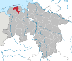
Wittmund is a Landkreis (district) in the northwestern part of Lower Saxony, Germany. It is situated in East Frisia, on the North Sea coast. Neighboring districts are (from the east clockwise) Friesland, Leer and Aurich.
The district contains part of the Wadden Sea and of the Lower Saxony Wadden Sea National Park. The coastal areas of the mainland are also known as Harlinger Land. The islands of Langeoog and Spiekeroog, both belonging to the East Frisian Islands, are part of this district.
The district was created by the Kingdom of Prussia in 1885 from the Amt Wittmund, the Amt Esens and the City of Esens. All were previously part of the District of Aurich. In 1977 the district was merged with the District of Friesland; however, the merger was not popular. The merger was declared unconstitutional in 1979 because it violated the rights of the former State of Oldenburg to which Friesland had belonged, and the two districts were re-established in their old boundaries.
The district has a partnership with the district of Schönebeck in Saxony-Anhalt. It was started with German reunification in 1990 to help to establish district administration in former East Germany.
...
Wikipedia

