Lower Saxony Wadden Sea National Park
| Lower Saxon Wadden Sea National Park | |
|---|---|
| Nationalpark Niedersächsisches Wattenmeer | |
|
IUCN category II (national park)
|
|

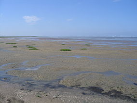
The Pilsumer Watt from the Leyhörn peninsula, East Frisia
|
|

Germany
|
|
| Location |
Lower Saxony, |
| Coordinates | 53°42′N 7°20′E / 53.700°N 7.333°ECoordinates: 53°42′N 7°20′E / 53.700°N 7.333°E |
| Area | 345.8 km2 (133.5 sq mi) |
| Established | January 1, 1986 |
| World Heritage Site | 2009 |
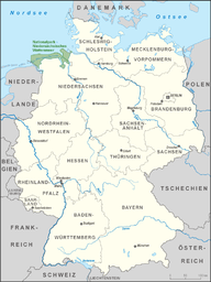
The Lower Saxon Wadden Sea National Park (German: Nationalpark Niedersächsisches Wattenmeer) was established in 1986 and embraces the East Frisian Islands, mudflats and salt marshes between the Bay of Dollart on the border with the Netherlands in the west and Cuxhaven as far as the Outer Elbe shipping channel in the east. The national park has an area of about 345,800 hectares (1,335 sq mi). The National Park organisation is located in Wilhelmshaven. Since June 2009 the Lower Saxon Wadden Sea National Park has become a UNESCO World Heritage Site along with the Schleswig-Holstein Wadden Sea and the Dutch Wadden Sea.
The habitats to be protected by this park include the mudflats, salt marshes, beaches, dunes and estuaries on the North Sea. Special attention is given to the wildlife and flora typical of the Wadden Sea of which the park forms a part.
The coast of the North Sea is unusually flat. The seabed descends in places only a few centimetres per kilometre. Twice daily the tide brings sand, clay and silt into the Wadden Sea. Dunes, formed by the wind out of fine grains of sand from the exposed mudflats, characterise the coast.
The Wadden Sea is the second most productive ecosystem after the tropical rainforest - only the latter surpasses the Wadden Sea in terms of its living biomass. The forms of life found in the Wadden Sea include diatoms, snails, worms, mussels and shrimp. A typical inhabitant of the sandy mudflats is the lugworm, which lives in a U-shaped tube under the surface of the mud.
...
Wikipedia
