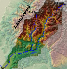
Wiesental, Germany
| Wiese | |
|---|---|

Location of the Wiese river
|
|
| Country | Germany, Switzerland |
| Basin features | |
| Main source | Black Forest |
| River mouth |
Rhine 47°34′58″N 7°35′13″E / 47.58278°N 7.58694°ECoordinates: 47°34′58″N 7°35′13″E / 47.58278°N 7.58694°E |
| Physical characteristics | |
| Length | 55 km (34 mi) |
The Wiese is a river in Baden-Württemberg, Germany, and Basel-City, Switzerland, a right tributary of the Rhine. It rises in the Black Forest, on the Feldberg. The Wiese flows through Todtnau, Schönau im Schwarzwald, Schopfheim and Lörrach. After crossing the border with Switzerland, the Wiese flows through the quarters of Basel on the right side of the Rhine, and joins the Rhine opposite the French town Saint-Louis. Its length is 55 km.
The largest tributary is the Little Wiese (German: Kleine Wiese, which is fed from the two headwaters the Köhlgartenwiese and the Belchen Wiesemeadow, which unite in Tegernau and form the Little Wiese. From Tegernau, the Little Wiese flows south and joins the Wiese west of Schopfheim.
Etymologically, the name Wiese is probably derived from the Old European root word virs or is- for water, or water, and has nothing to do with the German word Wiese, which means "meadow".
The Wiese rises on Mount Feldberg and flows as a mountain stream through a narrow valley with steep slopes in the Black Forest, past the towns of Fahl, Brandberg and Todtnau. After Todtnau, it flows past Geschwend and through the towns of Utzenfeld, Schönau im Schwarzwald, Wembach Fröhnd, and then past the villages of Mambach, Atzenbach and Zell im Wiesental.
...
Wikipedia
