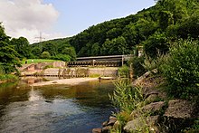
Wiese valley
| Wiese | |
|---|---|

The Wiese near Lörrach
|
|
| Location | Counties of Breisgau-Hochschwarzwald and Lörrach; Baden-Württemberg (Germany); Basel-Stadt (Switzerland) |
| Reference no. | DE: 232, CH: 541 |
| Basin features | |
| Main source | in the Black Forest between the Feldberg and the Grafenmatt ca. 1,218 m above sea level (NN) 47°51′24″N 8°01′31″E / 47.856611°N 8.02528°ECoordinates: 47°51′24″N 8°01′31″E / 47.856611°N 8.02528°E |
| River mouth | between the Basle quarters of Klybeck and Kleinhüningen into the Upper Rhine etwa 244 m above sea level (NN) 47°34′58″N 7°35′13″E / 47.58278°N 7.58694°E |
| Progression | Rhine → North Sea |
| River system | Rhine |
| Basin size | 453 km² |
| Tributaries |
|
| Physical characteristics | |
| Length | 57.76 km |
The Wiese is a river, 57.8 kilometres long, and a right-hand tributary of the Rhine in southwest Germany and northwest Switzerland.
From its source in Baden-Württemberg in theSouthern Black Forest on the mountain of the Feldberg, it flows for a short distance though the county of Breisgau-Hochschwarzwald and then mainly across Lörrach and through numerous settlements including the county town of Lörrach. After crossing the international border, the lower reaches of the river pass through the canton of Basel-Stadt, mainly through the city of Basle and through its district of Kleinbasel before emptying into the Upper Rhine.
The valley of the Wiese, which drains a catchment of 453 square miles, is called the Wiesental or Wiese Valley; it is oriented roughly towards the south-west. Its largest tributary is the Little Wiese (Kleine Wiese) which approaches from the north. The right-hand Rhine tributary of the Wiese and the left-hand Rhine tributaries of the Birsig, which discharges into the Rhine at the Basle port of Schifflände, and the Mühlebach, which flows under the Dreirosen Bridge, are the three biggest Upper Rhine tributaries on Swiss soil.
Etymologically, the name Wiese is probably derived from the Old European root word virs or is- for water, or water, and has nothing to do with the German word Wiese, which means "meadow".
The Wiese rises on the in the Black Forest in the Southern Black Forest Nature Park. Its source, the Wiesenquelle lies in the county of Breisgau-Hochschwarzwald immediately west of the residential area of Hebelhof in the municipality of Feldberg between the Feldberg (1,493 m above sea level (NHN)), the highest mountain in the range, to the northwest and the Grafenmatt (1,377.6 m) to the south-southwest at about 1,218 m. The section of the B 317 from Feldberg Ort via Hebelhof to Todtnau runs past the source a few metres to the north.
...
Wikipedia
