
Feldberg, Baden-Württemberg
| Feldberg | ||
|---|---|---|
|
||

Feldberg
|
||
|
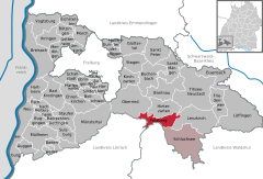
Location of Feldberg within Breisgau-Hochschwarzwald district
 _in_FR.svg) |
||
| Coordinates: 47°51′22″N 8°6′42″E / 47.85611°N 8.11167°ECoordinates: 47°51′22″N 8°6′42″E / 47.85611°N 8.11167°E | ||
| Country | Germany | |
| State | Baden-Württemberg | |
| Admin. region | Freiburg | |
| District | Breisgau-Hochschwarzwald | |
| Government | ||
| • Mayor | Stefan Wirbser | |
| Area | ||
| • Total | 24.97 km2 (9.64 sq mi) | |
| Elevation | 1,277 m (4,190 ft) | |
| Population (2015-12-31) | ||
| • Total | 1,912 | |
| • Density | 77/km2 (200/sq mi) | |
| Time zone | CET/CEST (UTC+1/+2) | |
| Postal codes | 79868 | |
| Dialling codes | 07676 / 07655 | |
| Vehicle registration | FR | |
| Website | www.feldberg-schwarzwald.de | |

Feldberg is a municipality in the district of Breisgau-Hochschwarzwald in Baden-Württemberg in southern Germany. It is located near the Feldberg, the highest summit in Baden-Württemberg. At an elevation of 1277m, it is considered the highest village in Germany.
The Feldberg municipality has the slogan "The highest in the Black Forest" (German: Das Höchste im Schwarzwald) and is located in the Southern Black Forest Nature Park at the Feldberg Pass. It is located between Wiesenthal (to the south) and Gutachtal (to the north). The largest section of the municipality is the "Falkau" area, where the town hall is located.
The current Feldberg municipality includes the three former Feldberg, Altglashütten, and Falkhau and consists of 30 villages, sections, farms, and cottages and houses.
The first mention of Feldberg was made in 983, but there was a separate municipality with the same name until January 1, 1939, when isolated pastures were combined with the municipality Bärental (970 m above sea level). They were previously owned by the municipalities Bernau, Brandenberg, Hinterzarten, Menzenschwand, St. William, Todtnau and Zastler. What was left of Brandenberg after incorporation to Feldberg became a new district in Todtnau.
The general election on May 25, 2014 resulted in the following allocation of seats within the local council:
There is an inter-municipality agreement with the neighbouring Schluchsee municipality.
In 1974, the ministry of the interior granted Dr. Alfred Simon permission to design the following crest: a red plate head holding two crossed silver snowshoes lies above a split silver and blue area. The blue section, on the left, holds three silver discs, and the silver section, on the right, holds a green fir tree.
The founder municipalities Feldberg, Bärental, and Altglashütten are represented by the three primary colours red, white, and blue. The blue also most likely represents the connection to the former House of Fürstenberg (Swabia). The meaning of the three discs leaves room for speculation. They are either reminiscent of glass spheres and glaziers or of the three lakes that meet within the boundary of Feldberg: Titisee, Windgfällweiher und Schluchsee. They could also symbolize the unity of the three communities.
...
Wikipedia