Wetterstein Mountains
| Wetterstein | |
|---|---|

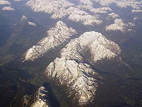
The Wetterstein and Mieming Chain (left) from the northeast
|
|
| Highest point | |
| Peak | Zugspitze |
| Elevation | 2,962 m (9,718 ft) |
| Coordinates | 47°25′0″N 10°59′42″E / 47.41667°N 10.99500°E |
| Geography | |

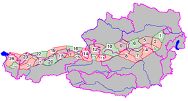
Groups of the Northern Limestone Alps
(purple lines showing international borders and the borders of Austrian states) |
|
| Countries | Austria and Germany |
| States | Tyrol and Bavaria |
| Range coordinates | 47°25′N 11°8′E / 47.417°N 11.133°ECoordinates: 47°25′N 11°8′E / 47.417°N 11.133°E |
| Parent range | Northern Limestone Alps |
| Geology | |
| Type of rock | Limestone |
The Wetterstein mountains (German: Wettersteingebirge), also simply called the Wetterstein, is a mountain group in the Northern Limestone Alps within the Eastern Alps. It is a relatively compact range located between Garmisch-Partenkirchen, Mittenwald, Seefeld in Tirol and Ehrwald. Part of it is in the German free state of Bavaria and part in the Austrian federal state of Tyrol. The main summit of the Wetterstein, the Zugspitze, is also the highest mountain in Germany.
The Wetterstein mountains are an ideal region for mountaineers and climbers. Mountain walkers sometimes need to allow for significant differences in elevation. The proximity of the range to the south German centres of population, the scenic landscape and its good network of cable cars and lifts mean that the mountains are heavily frequented by tourists for most of the year. There are, however, places in the Wetterstein that are rarely or never visited by people.
The Wetterstein borders on the following other mountain ranges of the Alps:
In the AVE, the Alpine Club classification of the Eastern Alps, the Wetterstein and the Mieming range are classed as a single group.
The River Loisach forms the boundary of the range to the west and north, from the Ehrwald Basin to Garmisch-Partenkirchen. To the northeast the boundary runs from Garmisch-Partenkirchen to Mittenwald along the Kankerbach and Kranzbach streams and the Isar river. To the east the Isar forms the boundary from Mittenwald to Scharnitz. South of Scharnitz it continues along the Drahnbach stream to Seestadeln. To the south the boundary extends from Ehrwald along the Gaisbach stream and over the Ehrwalder Alm to the Gaistal valley (Leutascher Ache) and continues via Leutasch-Oberweidach and past the Simmelberg to the north to the Drahnbach.
...
Wikipedia
