Wauwatosa, Wisconsin
| Wauwatosa, Wisconsin | |
|---|---|
| City | |

Wauwatosa along the banks
of the Menomonee River |
|
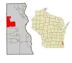
 Location of Wauwatosa, Wisconsin |
|
| Coordinates: 43°4′N 88°2′W / 43.067°N 88.033°WCoordinates: 43°4′N 88°2′W / 43.067°N 88.033°W | |
| Country | United States |
| State | Wisconsin |
| County | Milwaukee |
| Government | |
| • Mayor | Kathy Ehley |
| • Congressional Rep. | Jim Sensenbrenner (R) |
| Area | |
| • City | 13.25 sq mi (34.32 km2) |
| • Land | 13.25 sq mi (34.32 km2) |
| • Water | 0 sq mi (0 km2) 0% |
| Elevation | 673 ft (205 m) |
| Population (2010) | |
| • City | 46,396 |
| • Estimate (2012) | 47,068 |
| • Density | 3,501.6/sq mi (1,352.0/km2) |
| • Metro | 1,753,355 (Milwaukee) |
| Time zone | Central (UTC-6) |
| • Summer (DST) | CDT (UTC-5) |
| Area code(s) | 414 |
| FIPS code | 55-84675 |
| GNIS feature ID | 1576335 |
| Website | www |
Wauwatosa is a city in Milwaukee County, Wisconsin, United States. The population was 46,396 at the 2010 census. Wauwatosa is located immediately west of Milwaukee, and is a part of the Milwaukee metropolitan area. It is named after the Potawatomi word for firefly.
The lush Menomonee Valley of the Wauwatosa area provided a key overland gateway between the rich glacial farmland of southeastern Wisconsin and the Port of Milwaukee. In 1835, Charles Hart became the first Euro-American to settle here, followed that year by 17 other families. The following year a United States Road was built from Milwaukee through Wauwatosa, eventually reaching Madison. Charles Hart built a mill in 1845 on the Menomonee River which gave the settlement its original name of "Hart's Mill." The mill was torn down in 1914.
The Town of Wau-wau-too-sa was created by act of the Wisconsin Territorial Legislature on April 30, 1840. As of the 1840 census, the population of the Town of Wau-wau-too-sa or Wauwatosa was 342. The town government was organized in 1842. The town's borders originally extended from the present-day Greenfield Avenue in the south to Hampton Avenue in the north, and from 27th Street in the east to the Waukesha County line in the west, encompassing sections of present-day Milwaukee, West Milwaukee and West Allis, plus the southern part of former North Milwaukee, which was wholly annexed into the city of Milwaukee in 1927. Most of the town was farmland through the remainder of the 19th century.
In 1849 the Watertown Plank Road was constructed through Wauwatosa, mainly following the old Madison territorial road. In 1851 Wisconsin's first railroad (later The Milwaukee Road) established Wauwatosa as its western terminus. The Village of Wauwatosa was incorporated from the central part of the Town of Wauwatosa in 1892, and was rechartered as the City of Wauwatosa on May 27, 1897.
...
Wikipedia
