Washita River
| Washita River | |
|---|---|

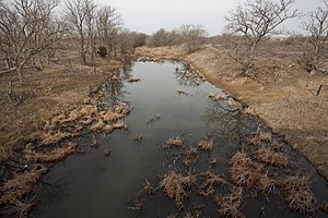
Upper Washita River in Hemphill County, Texas
|
|

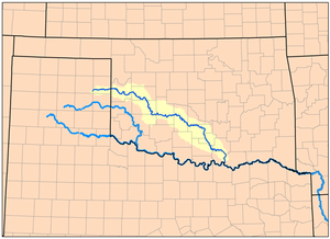
Map of the Washita River watershed
|
|
| Other name(s) | Ouachita, False Washita |
| Country | United States |
| Basin features | |
| Main source |
Roberts County, Texas 3,028 ft (923 m) 35°37′32″N 100°35′46″W / 35.6256003°N 100.5962467°W |
| River mouth |
Lake Texoma 617 ft (188 m) 33°54′42″N 96°34′41″W / 33.9117669°N 96.5780504°WCoordinates: 33°54′42″N 96°34′41″W / 33.9117669°N 96.5780504°W |
| River system | Red River |
| Basin size | 7,870 sq mi (20,400 km2) |
| Physical characteristics | |
| Length | 295 mi (475 km) |
The Washita River is a river in the states of Texas and Oklahoma in the United States. The river is 295 miles (475 km) long and terminates at its confluence with the Red River, which is now part of Lake Texoma (33°55′N 96°35′W / 33.917°N 96.583°W) on the Texas–Oklahoma border.
The Washita River forms in eastern Roberts County, Texas (35°38′N 100°36′W / 35.633°N 100.600°W), near the town of Miami in the Texas Panhandle. The river crosses Hemphill County, Texas and enters Oklahoma in Roger Mills County. It cuts through the Oklahoma counties of Roger Mills, Custer, Washita, Caddo, Grady, Garvin, Murray, Carter, and Johnston before emptying into Lake Texoma, which is the modern border between Bryan County and Marshall County.
...
Wikipedia
