Wahlenau
| Wahlenau | ||
|---|---|---|
|
||
| Coordinates: 49°54′22″N 7°15′1″E / 49.90611°N 7.25028°ECoordinates: 49°54′22″N 7°15′1″E / 49.90611°N 7.25028°E | ||
| Country | Germany | |
| State | Rhineland-Palatinate | |
| District | Rhein-Hunsrück-Kreis | |
| Municipal assoc. | Kirchberg | |
| Government | ||
| • Mayor | Rolf Müller | |
| Area | ||
| • Total | 4.46 km2 (1.72 sq mi) | |
| Elevation | 460 m (1,510 ft) | |
| Population (2015-12-31) | ||
| • Total | 188 | |
| • Density | 42/km2 (110/sq mi) | |
| Time zone | CET/CEST (UTC+1/+2) | |
| Postal codes | 55491 | |
| Dialling codes | 06543 | |
| Vehicle registration | SIM | |
| Website | www |
|
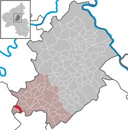
Wahlenau is an Ortsgemeinde – a municipality belonging to a Verbandsgemeinde, a kind of collective municipality – in the Rhein-Hunsrück-Kreis (district) in Rhineland-Palatinate, Germany. It belongs to the Verbandsgemeinde of Kirchberg, whose seat is in the like-named town.
The municipality lies in the Hunsrück, roughly 13 km westsouthwest of Kirchberg and 3 km south of Frankfurt-Hahn Airport. Wahlenau’s municipal area measures 4.46 km², of which 1.78 km² is wooded.
Witnessing early habitation in what is now Wahlenau is a group of Iron Age barrows in District 5 in the municipal forest. Archaeological finds from these are to be found at the Rheinisches Landesmuseum Bonn. Roman potsherds have also been found on the Via Ausonia (or Ausoniusstraße in German), which forms the southern municipal limit. According to a document from King Albrecht dated 27 October 1301, Count Johann II of Sponheim-Kreuznach held the Sohren Imperial fief, to which Wahlenau also belonged. Beginning in 1794, Wahlenau lay under French rule. In 1815 it was assigned to the Kingdom of Prussia at the Congress of Vienna. Since 1946, it has been part of the then newly founded state of Rhineland-Palatinate. In 1961, the Evangelical church was built.
...
Wikipedia


