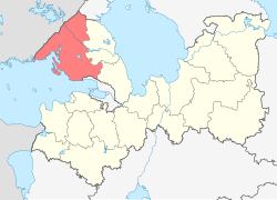
Vyborgsky District, Leningrad Oblast
Vyborgsky District (Russian: Вы́боргский райо́н) is an administrative and municipal district (raion), one of the seventeen in Leningrad Oblast, Russia. It is located in the northwest of the oblast on the Karelian Isthmus and borders with Priozersky District in the northeast, Vsevolozhsky District in the east, Kurortny District of the federal city of St. Petersburg in the south, Kymenlaakso and South Karelia regions of Finland in the northwest, and Lakhdenpokhsky District of the Republic of Karelia in the north. From the southwest, the district is limited by the Gulf of Finland. The area of the district is 7,475.472 square kilometers (2,886.296 sq mi). Its administrative center is the town of Vyborg. Population (excluding the administrative center): 120,446 (2010 Census); 113,748 (2002 Census);108,571 (1989 Census).
The district occupies the southwestern part of the Karelian Isthmus. The landscape is hilly and forested, with many rock formations. The northern part of the district lies in the basin of the Vuoksi River, which drains into Lake Ladoga. The Vuoksi itself crosses the district from northwest to southeast. Other rivers in the district, the largest of which are the Gryaznovka and the Sestra, drain directly into the Gulf of Finland. There are many lakes in the district, especially in the basin of the Vuoksi. Lake Glubokoye is the largest one.
...
Wikipedia


