Vieremä
| Vieremä | ||
|---|---|---|
| Municipality | ||
| Vieremän kunta | ||
|
||
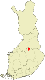
 Location of Vieremä in Finland |
||
| Coordinates: 63°44.5′N 027°00′E / 63.7417°N 27.000°ECoordinates: 63°44.5′N 027°00′E / 63.7417°N 27.000°E | ||
| Country |
|
|
| Region | Northern Savonia | |
| Sub-region | Upper Savonia sub-region | |
| Charter | 1922 | |
| Government | ||
| • Municipal manager | Ari Hukkanen | |
| Area (2016-01-01) | ||
| • Total | 925.26 km2 (357.24 sq mi) | |
| • Land | 925.18 km2 (357.21 sq mi) | |
| • Water | 48.2 km2 (18.6 sq mi) | |
| Area rank | 83rd largest in Finland | |
| Population (2016-03-31) | ||
| • Total | 3,735 | |
| • Rank | 205th largest in Finland | |
| • Density | 4.04/km2 (10.5/sq mi) | |
| Population by native language | ||
| • Finnish | 99.1% (official) | |
| • Others | 0.9% | |
| Population by age | ||
| • 0 to 14 | 15.9% | |
| • 15 to 64 | 63.2% | |
| • 65 or older | 20.9% | |
| Time zone | EET (UTC+2) | |
| • Summer (DST) | EEST (UTC+3) | |
| Municipal tax rate | 19.75% | |
| Website | www.vierema.fi | |
Vieremä is a municipality of Finland. It is located in the province of Eastern Finland and is part of the Northern Savonia region. The municipality has a population of 3,735 (31 March 2016) and covers an area of 925.26 square kilometres (357.24 sq mi) of which 48.2 km2 (18.6 sq mi) is water. The population density is 4.04 inhabitants per square kilometre (10.5/sq mi). Neighbouring municipalities are Iisalmi, Kajaani, Kiuruvesi, Pyhäntä, and Sonkajärvi. The municipality is unilingually Finnish.
Vieremä has an active musical life, despite its small size. Vieremä has long traditions in folk and religious music, and it is especially known for its active kantele-playing scene. A kantele camp for young players is organized every summer, and Vieremä church and Kyrönniemi Center of Culture and Religion host many concerts throughout the year.
Valkeiskylä, Kaarakkala, Karankamäki, Kirkonkylä, Rotimojoki, Nissilä, Palosenjärvi, Palosenmäki, Pyöree, Salahmi, and Savimäki.
...
Wikipedia

