Vermont Route 14
| Vermont Route 14 | |||||||
|---|---|---|---|---|---|---|---|

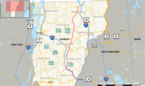
Map of northern Vermont with VT 14 highlighted in red
|
|||||||
| Route information | |||||||
| Maintained by VTrans | |||||||
| Length: | 108.946 mi (175.332 km) | ||||||
| Existed: | 1922 – present | ||||||
| Major junctions | |||||||
| South end: |
|
||||||
|
|||||||
| North end: |
|
||||||
| Location | |||||||
| Counties: | Windsor, Orange, Washington, Caledonia, Orleans | ||||||
| Highway system | |||||||
|
|||||||
Vermont Route 14 is a north–south state highway in northeastern Vermont, United States. It is 110.2 miles (177.3 km) long and extends from U.S. Route 4 and U.S. Route 5 in White River Junction to Vermont Route 100 in Newport. Between White River Junction and the city of Barre, the route parallels Interstate 89. Vermont Route 14 was originally designated in 1922 as part of the New England road marking system. Its north end was truncated in 1926 as a result of the designation of U.S. Route 2 but was extended north along an old alignment of Vermont Route 12 in the 1960s.
VT 14 begins at the intersection of US 4 and US 5 in White River Junction in the town of Hartford, at the confluence of the White River and the Connecticut River. VT 14 heads northwest as Maple Street, crossing under I-91 without an interchange, and continues through the town center of Hartford, along the north bank of the White River. 5 miles (8 km) later it passes through the small village of West Hartford and soon enters the town of Sharon. After traveling another 5 miles (8 km) along the river, VT 14 intersects with VT 132 in Sharon center and continues northwest into the town of Royalton, where it passes through the town's three villages along the White River. VT 14 first goes through South Royalton, where it has a junction with VT 110, then continues to follow the winding path of the river through Royalton center, finally reaching the village of North Royalton, where it meets with VT 107. From here, VT 14 turns north, leaving the main White River to follow the Second Branch of the White River. VT 14 runs for about 3 miles (5 km) in western Royalton town, then enters the village of East Bethel in the town of Bethel. Less than 1 mile (1.6 km) later, VT 14 enters the town of Randolph, passing through the village of South Randolph. After traveling north for another 4.5 miles (7.2 km), VT 14 arrives in the village of East Randolph, where it has a junction with VT 66, which is signed for the Randolph town center.
...
Wikipedia

