Bethel, Vermont
| Bethel, Vermont | |
|---|---|
| Town | |

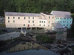
Old mill buildings in Bethel, Vermont
|
|
 Location in Windsor County and the state of Vermont. |
|
| Location in the United States | |
| Coordinates: 43°50′40″N 72°38′46″W / 43.84444°N 72.64611°WCoordinates: 43°50′40″N 72°38′46″W / 43.84444°N 72.64611°W | |
| Country | United States |
| State | Vermont |
| County | Windsor |
| Chartered | 1779 (Vermont) |
| Area | |
| • Total | 45.4 sq mi (117.7 km2) |
| • Land | 45.2 sq mi (117.0 km2) |
| • Water | 0.3 sq mi (0.7 km2) |
| Elevation | 573 ft (256 m) |
| Population (2010) | |
| • Total | 2,030 |
| • Density | 45/sq mi (17/km2) |
| • Households | 817 |
| • Families | 548 |
| Time zone | EST (UTC-5) |
| • Summer (DST) | EDT (UTC-4) |
| ZIP code | 05032 |
| Area code(s) | 802 |
| FIPS code | 50-05800 |
| GNIS feature ID | 1462043 |
| Website | bethelvt |
Bethel is a town in Windsor County, Vermont, United States. The population was 2,030 at the 2010 census. The town includes the locations of Bethel village, Bethel-Gilead, East Bethel, Lilliesville, Lympus (formerly Olympus), and West Bethel. Bethel is best known for being the source of Bethel White granite which was used to build Union Station (Washington, D.C.) and the National Museum of Natural History. Bethel was the first town created by the independent Republic of Vermont in 1779 and was named after the Biblical village of Bethel.
According to the United States Census Bureau, the town has a total area of 45.4 square miles (117.7 km2), of which 45.2 square miles (117.0 km2) is land and 0.27 square miles (0.7 km2), or 0.58%, is water.
Bethel is crossed by Interstate 89 (Exit 3 serves the town), Vermont Route 12 and Vermont Route 107. Amtrak's Vermonter train, operating daily between St. Albans and Washington, DC also passes through, but does not stop in town as it traverses the New England Central Railroad. The closest stations are Randolph to the north and White River Junction to the southeast.
...
Wikipedia

