East Montpelier, Vermont
| East Montpelier, Vermont | |
|---|---|
| Town | |
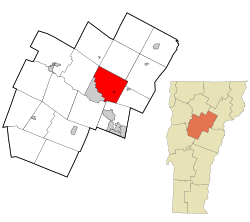
 Location in Washington County and the state of Vermont |
|
| Location in the United States | |
| Coordinates: 44°17′14″N 72°30′11″W / 44.28722°N 72.50306°WCoordinates: 44°17′14″N 72°30′11″W / 44.28722°N 72.50306°W | |
| Country | United States |
| State | Vermont |
| County | Washington |
| Incorporated (town) | 1895 |
| Area | |
| • Total | 32.1 sq mi (83.2 km2) |
| • Land | 31.9 sq mi (82.5 km2) |
| • Water | 0.3 sq mi (0.7 km2) |
| Elevation | 1,070 ft (326 m) |
| Population (2010) | |
| • Total | 2,576 |
| • Density | 80/sq mi (31/km2) |
| Time zone | Eastern (EST) (UTC-5) |
| • Summer (DST) | EDT (UTC-4) |
| ZIP codes | 05651, 05667 |
| Area code(s) | 802 |
| FIPS code | 50-21925 |
| GNIS feature ID | 1462087 |
East Montpelier /ˌiːst mɒntˈpiːliər/ is a town in Washington County, Vermont, United States. The population was 2,576 at the 2010 census.
According to the United States Census Bureau, the town has a total area of 32.1 square miles (83.1 km2), of which 32.0 square miles (82.9 km2) is land and 0.1 square mile (0.3 km2) (0.34%) is water.
The town is bordered by Montpelier, the state capital, to the southwest, by Middlesex to the northwest, by Calais to the northeast, by Marshfield to the east, by Plainfield to the southeast, and by the town of Barre to the south. The town of Worcester touches the northern corner of East Montpelier at a single point.
Villages in the town include East Montpelier (the primary settlement), East Montpelier Center, North Montpelier, and a portion of Adamant.
At the 2000 census, there were 2,578 people, 1,007 households and 730 families residing in the town. The population density was 80.6 per square mile (31.1/km2). There were 1,055 housing units at an average density of 33.0 per square mile (12.7/km2). The racial makeup of the town was 96.39% White, 0.78% African American, 0.70% Native American, 0.39% Asian, 0.04% Pacific Islander, 0.04% from other races, and 1.67% from two or more races. Hispanic or Latino of any race were 1.12% of the population.
...
Wikipedia

