Velikoluksky District
| Velikoluksky District Великолукский район (Russian) |
|
|---|---|
 Location of Velikoluksky District in Pskov Oblast |
|
| Coordinates: 56°20′N 30°32′E / 56.333°N 30.533°ECoordinates: 56°20′N 30°32′E / 56.333°N 30.533°E | |
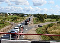
 The Baltic Highway in Velikoluksky District |
|
|
|
|
| Location | |
| Country | Russia |
| Federal subject | Pskov Oblast |
| Administrative structure (as of February 2009) | |
| Administrative center | town of Velikiye Luki |
| Inhabited localities: | |
| Rural localities | 452 |
| Municipal structure (as of April 2011) | |
| Municipally incorporated as | Velikoluksky Municipal District |
| Municipal divisions: | |
| Urban settlements | 0 |
| Rural settlements | 11 |
| Statistics | |
| Area | 2,960 km2 (1,140 sq mi) |
| Population (2010 Census) | 22,121 inhabitants |
| • Urban | 0% |
| • Rural | 100% |
| Density | 7.47/km2 (19.3/sq mi) |
| Time zone | MSK (UTC+03:00) |
| Official website | |
| on | |
Velikoluksky District (Russian: Великолу́кский райо́н) is an administrative and municipal district (raion), one of the twenty-four in Pskov Oblast, Russia. It is located in the southeast of the oblast and borders with Loknyansky District in the north, Toropetsky District of Tver Oblast in the northeast, Kunyinsky District in the east, Usvyatsky District in the south, Nevelsky District in the southwest, and with Novosokolnichesky District in the west. The area of the district is 2,960 square kilometers (1,140 sq mi). Its administrative center is the town of Velikiye Luki (which is not administratively a part of the district). Population: 22,121 (2010 Census); 24,035 (2002 Census);31,911 (1989 Census).
The district is elongated from north to south and lies completely in the basin of the Lovat River, which crosses it from south to north. The biggest tributary of the Lovat within the limits of the district is the Kunya River. The northern part of the district is a flat depression, whereas the southern one is a hilly plain of glacial origin, filled with lakes, the biggest of which is Lake Uritskoye.
...
Wikipedia


