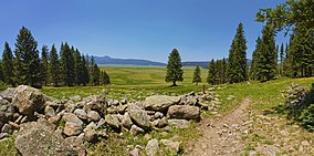
Valles Caldera National Preserve
| Valles Caldera National Preserve | |
|---|---|
|
IUCN category V (protected landscape/seascape)
|
|

Valles Caldera
|
|
| Location | Sandoval and Rio Arriba counties, New Mexico, United States |
| Nearest city | Los Alamos, NM |
| Coordinates | 35°54′00″N 106°31′59″W / 35.9°N 106.533°WCoordinates: 35°54′00″N 106°31′59″W / 35.9°N 106.533°W |
| Area | 89,216 acres (361.04 km2) |
| Established | July 25, 2000 |
| Governing body | National Park Service |
| Website | Valles Caldera National Preserve |
| Designated | 1975 |
The Valles Caldera National Preserve is a national preserve located in northeastern Sandoval County and southern Rio Arriba County, just west of Los Alamos. It protects a large portion of the Valles Caldera, an area of significant geological, ecological and cultural interest. It has a land area of 89,216 acres (139.400 sq mi; 361.04 km2) and until 2015 was administered by the Valles Caldera Trust with offices in Jemez Springs. In 2014 legislation attached to the Defense Authorization Act authorized the transfer of the preserve to the National Park Service and dissolution of the Valles Caldera Trust. The transfer to NPS management took place on October 10, 2015.
The Valles Caldera Preservation Act of 2000 signed by President Clinton on July 25, 2000, created the Valles Caldera National Preserve (VCNP). The legislation provided for the federal purchase of the land, previously the privately held Baca ranch. The surface estate of 95,000 acres (380 km2) and seven-eighths of the geothermal mineral estate were purchased by the federal government for $101 million. Funds for the purchase were obtained through the Land and Water Conservation Fund (LWCF) from federal government royalties received from offshore petroleum and natural gas drilling. Some areas of the Baca Ranch are of cultural significance to Native Americans. Accordingly, 5,000 acres (20 km2) of the purchase were obtained by the Santa Clara Pueblo, which borders the property to the northeast. These include the headwaters of Santa Clara Creek, considered sacred by the Pueblo. On the southwest corner of the land 300 acres (1.2 km2) were to be ceded to Bandelier National Monument.
...
Wikipedia

