Los Alamos, New Mexico
| Los Alamos, New Mexico | |
|---|---|
| Census-designated place | |

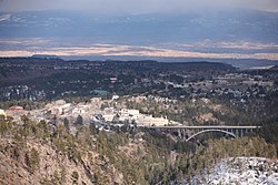
View from Camp May Trail
|
|
| Nickname(s): Atomic City; The Hil; Site Y (past) |
|
| Motto: Where discoveries are made | |
 Location of Los Alamos, New Mexico |
|
| Coordinates: 35°53′28″N 106°17′52″W / 35.89111°N 106.29778°WCoordinates: 35°53′28″N 106°17′52″W / 35.89111°N 106.29778°W | |
| Country | United States |
| State | New Mexico |
| County | Los Alamos |
| Area | |
| • Total | 11.1 sq mi (28.1 km2) |
| • Land | 11.1 sq mi (28.1 km2) |
| • Water | 0.0 sq mi (0.0 km2) |
| Elevation | 7,320 ft (2,231 m) |
| Population (2010) | |
| • Total | 12,019 |
| • Density | 1,102/sq mi (427.7/km2) |
| Time zone | Mountain (MST) (UTC-7) |
| • Summer (DST) | MDT (UTC-6) |
| ZIP codes | 87544-87545 |
| Area code(s) | 505 |
| FIPS code | 35-42320 |
| GNIS feature ID | 0901357 |
Los Alamos (Spanish: Los Álamos, meaning "The Cottonwoods") is a town in Los Alamos County, New Mexico, United States. It is the county seat and one of two population centers in the county known as census-designated places (CDPs); the other is White Rock. Los Alamos is located on four mesas of the Pajarito Plateau. Los Alamos is home to the Los Alamos National Laboratory, established in 1943 for the Manhattan Project. Previously, the site was occupied by the Los Alamos Ranch School. The population was 12,019 at the 2010 Census.
Los Alamos is built on the Pajarito Plateau between White Rock Canyon and the Valles Caldera. The first settlers on the plateau are thought to be Keres speaking Native Americans around the 10th century. Around 1300, Tewa settlers immigrated from the Four Corners Region and built large cities but were driven out within 50 years by Navajo and Apache raids and by drought. Both the Keres and Tewa towns can be seen today in the ruins of Bandelier National Monument and Tsankawi.
The land of the plateau was then divided up for homesteading. Most residents of the plateau built simple log cabins that they only lived in during warm weather to feed livestock, with the homesteaders moving down to the warmer Rio Grande Valley. Homesteader Harold H. Brook sold part of his land and buildings to Detroit businessman Ashley Pond II in 1917 which began the Los Alamos Ranch School, named after the aspen trees that blossomed in the spring.
...
Wikipedia
