Bandelier National Monument
| Bandelier National Monument | |
|---|---|
|
IUCN category III (natural monument or feature)
|
|

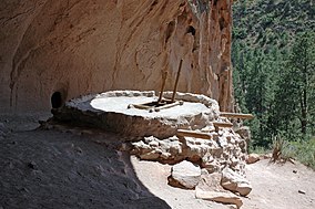
Reconstructed kiva at Alcove House
|
|
| Location | Sandoval, Los Alamos and Santa Fe counties, New Mexico, United States |
| Nearest town | Los Alamos, New Mexico |
| Coordinates | 35°46′44″N 106°19′16″W / 35.77889°N 106.32111°WCoordinates: 35°46′44″N 106°19′16″W / 35.77889°N 106.32111°W |
| Area | 33,677 acres (136.29 km2) |
| Created | February 11, 1916 |
| Visitors | 150,289 (in 2012) |
| Governing body | National Park Service |
| Website | Bandelier National Monument |
|
Bandelier National Monument
|
|
| Built | 1200 |
| NRHP Reference # |
66000042 (original) 14001017 (increase) |
| NMSRCP # | 56 |
| Significant dates | |
| Added to NRHP | October 15, 1966 |
| Boundary increase | December 10, 2014 |
| Designated NMSRCP | May 21, 1971 |
Bandelier National Monument is a 33,677-acre (13,629 ha) United States National Monument in New Mexico preserving the homes and territory of the Ancestral Puebloans of a later era in the Southwest. Most of the pueblo structures date to two eras, in total from 1150 to 1600 AD.
The Monument is 50 square miles (130 km2) of the Pajarito Plateau, on the slopes of the Jemez Volcanic field in the Jemez Mountains. Over 70% of the Monument is wilderness, with over one mile elevation change, from about 5,000 feet (1,500 m) along the Rio Grande to over 10,000 feet (3,000 m) at the peak of Cerro Grande on the rim of the Valles Caldera, providing for a wide range of life zones and wildlife habitats. There are three miles of road, and more than 70 miles of hiking trails. The Monument protects Ancestral Pueblo archeological sites, a diverse and scenic landscape, and the country's largest National Park Service Civilian Conservation Corps National Landmark District.
Bandelier was designated by President Woodrow Wilson as a National Monument on February 11, 1916, and named for Adolph Bandelier, a Swiss-American anthropologist who researched the cultures of the area and supported preservation of the sites. The National Park Service co-operates with surrounding pueblos, other federal agencies, and state agencies to manage the park. The monument received 193,914 visitors in 2011.
In October 1976, roughly seventy percent of the monument, 23,267 acres (9,416 ha), was included within the National Wilderness Preservation System. The park's elevations range from about 5,000 feet (1,500 m) at the Rio Grande to over 10,200 feet (3,100 m) at the summit of Cerro Grande. The Valles Caldera National Preserve adjoins the monument on the north and west, extending into the Jemez Mountains.
...
Wikipedia


