Valcour Island

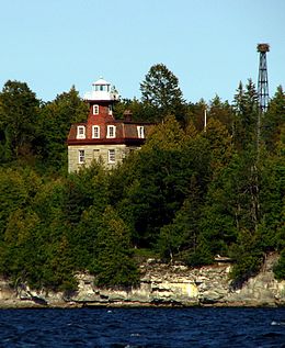
Bluff Point Light on Valcour Island. The steel tower at right held the light from 1930 to 2002. In this photo, it holds an Osprey nest.
|
|
| Location of Valcour Island in New York State | |
| Geography | |
|---|---|
| Location | Lake Champlain |
| Coordinates | 44°37′18″N 73°25′02″W / 44.62167°N 73.41722°WCoordinates: 44°37′18″N 73°25′02″W / 44.62167°N 73.41722°W |
| Area | 968 acres (392 ha) |
| Length | 2 mi (3 km) |
| Width | 1 mi (2 km) |
| Highest elevation | 148 ft (45.1 m) |
| Administration | |
| State | New York |
| County | Clinton |
| Towns | Peru, Plattsburgh |
| Owner | New York State Department of Environmental Conservation |
Valcour Island is a 968-acre (3.92 km2)island in Lake Champlain in Clinton County, New York, United States. The island is mostly in the Town of Peru and partly in the Town of Plattsburgh, southeast of the City of Plattsburgh. It is within the boundaries of the Adirondack Park.
Valcour Island, about two miles (3.2 km) long and one mile (1.6 km) wide, lies by the western shore of Lake Champlain, forming one side of a narrow strait against the New York mainland. Its shores are alternately rocky, craggy outcroppings and sandy beaches. Several protected bays provide anchorages. The Bluff Point Light stands on the western shore. It guided boats through the narrow strait from 1871 until 1930 when it was replaced by a steel tower.
It is the fourth-largest island in Lake Champlain. The only larger Islands are Grand Isle, North Hero and Isle la Motte, all part of Vermont.
The island contains part of an exposed Ordovician fossil reef, and was dedicated as part of the Chazy Fossil Reef National Natural Landmark in 2009.
On October 11, 1776, a naval engagement known as the Battle of Valcour Island between British and United States naval forces under Benedict Arnold was fought in the strait adjacent to the island.
...
Wikipedia

