Utopia, Texas
| Utopia, Texas | |
|---|---|
| Census-designated place | |
| Nickname(s): "An Ideally, Perfect Place" | |
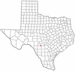
 Location of Utopia, Texas |
|
 |
|
| Coordinates: 29°36′59″N 99°31′36″W / 29.61639°N 99.52667°WCoordinates: 29°36′59″N 99°31′36″W / 29.61639°N 99.52667°W | |
| Country | United States |
| State | Texas |
| County | Uvalde |
| Area | |
| • Total | 3.0 sq mi (7.6 km2) |
| • Land | 3.0 sq mi (7.6 km2) |
| • Water | 0.0 sq mi (0.0 km2) |
| Elevation | 1,362 ft (415 m) |
| Population (2010) | |
| • Total | 227 |
| • Density | 76/sq mi (30/km2) |
| Time zone | Central (CST) (UTC-6) |
| • Summer (DST) | CDT (UTC-5) |
| ZIP code | 78884 |
| Area code(s) | 830 |
| FIPS code | 48-74576 |
| GNIS feature ID | 1349137 |
| Website | www.utopiatexas.info |
Utopia is a census-designated place (CDP) in Uvalde County, Texas, United States. The population was 227 at the 2010 census.
The citizens of the earlier settlement of Waresville renamed their city Utopia after finding "Montana, Texas," had already been taken. To this day the cemetery is named for Waresville. A planned utopian community nearby was cancelled after the failure of La Reunion near Dallas discouraged colonizers. The nearby city of Castroville was founded by French (Alsatian) settlers.
Utopia is located at 29°36′59″N 99°31′36″W / 29.61639°N 99.52667°W (29.616402, -99.526623).
According to the United States Census Bureau, the CDP has a total area of 3.0 square miles (7.6 km²), all of it land.
According to the Köppen Climate Classification system, Utopia has a humid subtropical climate, abbreviated "Cfa" on climate maps.
As of the census of 2000, there were 241 people, 111 households, and 69 families residing in the CDP. The population density was 81.6 people per square mile (31.5/km²). There were 127 housing units at an average density of 43.0/sq mi (16.6/km²). The racial makeup of the CDP was 93.36% White, 0.41% Native American, 4.56% from other races, and 1.66% from two or more races. Hispanic or Latino of any race were 8.30% of the population.
...
Wikipedia
