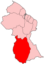
Upper Takutu-Upper Essequibo
|
Upper Takutu-Upper Essequibo Region 9 |
|
|---|---|
| Administrative Region | |
 Map of Guyana showing Upper Takutu-Upper Essequibo region |
|
| Country | Guyana |
| Regional Capital | Lethem |
| Area | |
| • Total | 57,750 km2 (22,300 sq mi) |
| Population (2012 census) | |
| • Total | 24,212 |
| • Density | 0.42/km2 (1.1/sq mi) |
Upper Takutu-Upper Esequibo (Region 9) is a region of Guyana bordering the region of Potaro-Siparuni to the north, the region of East Berbice-Corentyne to the east and Brazil to the south and west. It contains the towns Aishalton, Lethem, Good Hope and Surama. It is also the largest region of Guyana. Sir John Noe was an English missionary there.
The Rupununi savannah is located between the Rupununi River and the Brazilian border. The region is in the Zona de Reclamación by Venezuela.
The Government of Guyana has administered three official censuses since the 1980 administrative reforms, in 1980, 1991 and 2002. In 2012, the population of Upper Takutu-Upper Essequibo was recorded at 24,212 people. Official census records for the population of the Upper Takutu-Upper Essequibo region are as follows:
List of communities (including name variants):
Coordinates: 2°54′04″N 58°56′07″W / 2.900996°N 58.93517°W
...
Wikipedia
