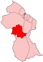
Potaro-Siparuni
|
Potaro-Siparuni Region 8 |
|
|---|---|
| Administrative Region | |
 Map of Guyana showing Potaro-Siparuni region |
|
| Country | Guyana |
| Regional Capital | Mahdia |
| Area | |
| • Total | 20,051 km2 (7,742 sq mi) |
| Population (2012 census) | |
| • Total | 10,190 |
| • Density | 0.51/km2 (1.3/sq mi) |
Potaro-Siparuni (Region 8) is a region in Guyana, bordering the region of Cuyuni-Mazaruni to the north, the regions of Upper Demerara-Berbice and East Berbice-Corentyne to the east, the region of Upper Takutu-Upper Essequibo to the south and Brazil to the west.
The main towns in the region are Kangaruma, Orinduik, Potaro Landing, Mahdia, Saveretik and Tumatumari.
The Government of Guyana has administered three official censuses since the 1980 administrative reforms, in 1980, 1991 and 2002. In 2012, the population of Potaro-Siparuni was recorded at 10,190 people. Official census records for the population of Potaro-Siparuni are as follows:
(including name variants):
Coordinates: 4°46′11″N 59°15′55″W / 4.769702°N 59.265391°W
...
Wikipedia
