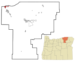
Umatilla, Oregon
| Umatilla, Oregon | |
|---|---|
| City | |

Umatilla Marina, Umatilla Bridge, and McNary Dam
|
|
| Motto: Catch the vision | |
 Location in Oregon |
|
| Coordinates: 45°55′2″N 119°20′33″W / 45.91722°N 119.34250°WCoordinates: 45°55′2″N 119°20′33″W / 45.91722°N 119.34250°W | |
| Country | United States |
| State | Oregon |
| County | Umatilla |
| Incorporated | 1864 |
| Government | |
| • Mayor | David P. Trott |
| Area | |
| • Total | 4.63 sq mi (11.99 km2) |
| • Land | 4.42 sq mi (11.45 km2) |
| • Water | 0.21 sq mi (0.54 km2) |
| Elevation | 322 ft (98 m) |
| Population (2010) | |
| • Total | 6,906 |
| • Estimate (2012) | 7,010 |
| • Density | 1,562.4/sq mi (603.2/km2) |
| Time zone | Pacific (UTC-8) |
| • Summer (DST) | Pacific (UTC-7) |
| ZIP code | 97882 |
| Area code(s) | 541 |
| FIPS code | 41-75650 |
| GNIS feature ID | 1128399 |
| Website | www.umatilla-city.org |
Umatilla (/ˌjuːməˈtɪlə/, YOO-mə-TIL-ə) is a city in Umatilla County, Oregon, United States. It is named for the Umatilla River, which enters the Columbia River on the side of the city. The river is named after the Umatilla Tribe. The city is on the south side of the Columbia River along U.S. Route 730 and I-82.
The Umatilla Chemical Depot, and the Umatilla Chemical Agent Disposal Facility, is 6 miles (10 km) southwest of the city, northwest of the intersection of I-84 and I-82. The estimated population in 2012 was 7,010.
Umatilla is part of the Pendleton–Hermiston Micropolitan Statistical Area.
The first Umatilla post office was established in September 1851 at the Umatilla Indian Agency about 5 miles (8 km) east of Pendleton, and discontinued in January 1852. This was before Timothy K. Davenport surveyed for a town site at the mouth of the Umatilla River in 1862. The site was first known as Umatilla Landing, then Umatilla City, then Columbia, then Umatilla City once again over the next year or so. Its post office was established in 1863 with Z. F. Moody as postmaster.
...
Wikipedia
