U.S. Route 66 in Arizona
| U.S. Route 66 | ||||
|---|---|---|---|---|
| Will Rogers Highway | ||||
 |
||||
| Route information | ||||
| Maintained by AZDOT (I-40 Bus., SR 66); county and local gov'ts | ||||
| Length: | 401 mi (645 km) | |||
| Existed: | November 11, 1926 – June 26, 1985 | |||
| Major junctions | ||||
| West end: |
|
|||
| East end: |
|
|||
| Highway system | ||||
|
||||
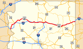
U.S. Route 66 (US 66, Route 66) covered 401 miles (645 km) as part of a former United States Numbered Highway in the state of Arizona. The highway ran from west to east, starting in Needles, California, through Kingman and Seligman to the New Mexico state line as part of the historic US 66 from Santa Monica, California, to Chicago, Illinois. The highway was decommissioned in 1985, although portions remain as State Route 66 (SR 66).
In 1914 the road was designated "National Old Trails Highway"; in 1926 it was re-designated as US 66. One section just outside Oatman, Arizona, through the Black Mountains, was fraught with hairpin turns and was the steepest along the entire route, so much so that some early travellers, too frightened at the prospect of driving such a potentially dangerous road, hired locals to navigate the winding grade. The section remained as Route 66 until 1953, and is still open to traffic today as the Oatman Highway.
On October 13, 1984, Williams, Arizona, was the last point on US 66 to be bypassed by an Interstate highway. US 66 was dropped from the US Highway system in 1985; parts of the highway were either absorbed into Interstate 40 (I-40), turned over to the state (SR 66), or turned over to Yavapai County.
...
Wikipedia

