U.S. Route 59 in Arkansas
| U.S. Route 59 | |
|---|---|
 |
|
| Route information | |
| Length: | 1,911 mi (3,075 km) |
| Existed: | 1934 – present |
| Major junctions | |
| South end: |
|
|
|
| North end: |
|
| Location | |
| States: | Texas, Arkansas, Oklahoma, Kansas, Missouri, Iowa, Minnesota |
| Highway system | |
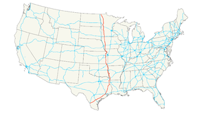
U.S. Route 59 is a north–south United States highway (though it is signed east–west in parts of Texas). A latecomer to the U.S. numbered route system, US 59 is now a border-to-border route, part of NAFTA Corridor Highway System. It parallels U.S. Route 75 for nearly its entire route, never much more than 100 miles (160 km) away, until it veers southwest in Houston, Texas. Its number is out of place since US 59 is either concurrent with or entirely west of U.S. Route 71.
The highway's northern terminus is nine miles (14 km) north of Lancaster, Minnesota, at the Canada–US border, where it continues as Manitoba Highway 59. Its southern terminus is at the Mexico–US border in Laredo, Texas, where it continues as Mexican Federal Highway 85D.
U.S. Highway 59 (US 59) in the U.S. state of Texas is named the Lloyd Bentsen Highway, after Lloyd Bentsen, former U.S. Senator from Texas. In northern Houston, US 59, co-signed with Interstate 69 (I-69), is the Eastex Freeway (from Downtown Houston to the Liberty County/Montgomery County line). To the south, which is also co-signed with I-69, it is the Southwest Freeway (from Rosenberg to Downtown Houston), which is one of the busiest sections of freeway in the United States with a vehicle count, as of 2006, over 330,000 vehicles per day just outside the Loop.
...
Wikipedia

