U.S. Route 27 (Ohio)
| U.S. Route 27 | |
|---|---|
 |
|
| Route information | |
| Length: | 1,373 mi (2,210 km) |
| Existed: | 1926 – present |
| Major junctions | |
| South end: |
|
|
|
| North end: |
|
| Location | |
| States: | Florida, Georgia, Tennessee, Kentucky, Ohio, Indiana |
| Highway system | |
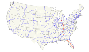
U.S. Route 27 (US 27) is a north–south United States highway in the southern and midwestern United States. The southern terminus is at US 1 in Miami, Florida. The northern terminus is at Interstate 69 (I-69) in Fort Wayne, Indiana. From Miami it goes up the center of Florida, then west to Tallahassee, Florida, and north through such cities and towns as Columbus, Georgia; Rome, Georgia; Chattanooga, Tennessee; Lexington, Kentucky; Cincinnati, Ohio; Oxford, Ohio; Richmond, Indiana; and Fort Wayne, Indiana. It once extended north through Lansing, Michigan, to Cheboygan, Mackinaw City, and for about 3 years as far as St. Ignace.
US 27 appeared in 1926, replacing what had been the western route of the Dixie Highway in many places.
...
Wikipedia

