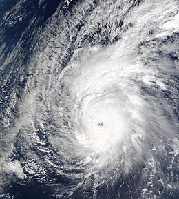
Typhoon Pongsona
| Typhoon (JMA scale) | |
|---|---|
| Category 4 (Saffir–Simpson scale) | |

Typhoon Pongsona near peak intensity on December 8
|
|
| Formed | December 2, 2002 |
| Dissipated | December 12, 2002 |
| (Extratropical after December 11) | |
| Highest winds |
10-minute sustained: 165 km/h (105 mph) 1-minute sustained: 240 km/h (150 mph) |
| Lowest pressure | 940 hPa (mbar); 27.76 inHg |
| Fatalities | 1 indirect |
| Damage | $730 million (2002 USD) |
| Areas affected | Guam, Northern Mariana Islands |
| Part of the 2002 Pacific typhoon season | |
Typhoon Pongsona was the last typhoon of the 2002 Pacific typhoon season, and was the second costliest United States disaster in 2002, only behind Hurricane Lili. The name "Pongsona" was contributed by North Korea for the Pacific tropical cyclone list and is the Korean name for the garden balsam. Pongsona developed out of an area of disturbed weather on December 2, and steadily intensified to reach typhoon status on December 5. On December 8 it passed through Guam and the Northern Mariana Islands while near its peak winds of 175 km/h (110 mph 10-min). It ultimately turned to the northeast, weakened, and became extratropical on December 11.
Typhoon Pongsona produced strong wind gusts peaking at 278 km/h (173 mph 1-min), which left the entire island of Guam without power and destroyed about 1,300 houses. With strong building standards and experience from repeated typhoon strikes, there were no fatalities directly related to Pongsona, although there was one indirect death from flying glass. Damage on the island totaled over $700 million (2002 USD, $932 million 2017 USD), making Pongsona among the five costliest typhoons on the island. The typhoon also caused heavy damage on Rota and elsewhere in the Northern Mariana Islands, and as a result of its impact the name was retired.
During late November, an area of convection persisted about 625 kilometers (390 mi) east-southeast of Pohnpei. Satellite imagery indicated broad cyclonic turning in the lower levels of the atmosphere, and a trough was located near the surface. The disturbance developed rainbands and gradually became better organized. By December 2, the system had an elongated low-level circulation, located to the south of the convection. At 0600 UTC that day, the Japan Meteorological Agency (JMA) classified the system as a tropical depression about 735 km (450 mi) east-northeast of Pohnpei. Shortly thereafter, the Joint Typhoon Warning Center (JTWC) issued a Tropical Cyclone Formation Alert, and at 1800 UTC on December 2 the agency classified the system as Tropical Depression 31W. Initially the depression moved to the west-northwest, and early on December 3 the JTWC classified the system as a tropical storm.
...
Wikipedia
