Typhoon Phanfone (2014)
| Typhoon (JMA scale) | |
|---|---|
| Category 4 (Saffir–Simpson scale) | |

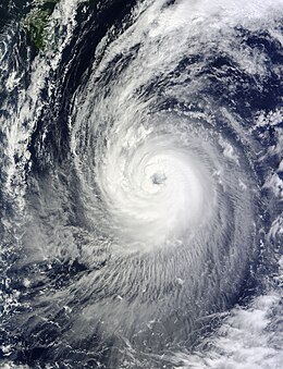
Typhoon Phanfone situated between the Northern Mariana Islands and Japan on October 3
|
|
| Formed | September 28, 2014 |
| Dissipated | October 12, 2014 |
| (Extratropical after October 6) | |
| Highest winds |
10-minute sustained: 175 km/h (110 mph) 1-minute sustained: 250 km/h (155 mph) |
| Lowest pressure | 935 hPa (mbar); 27.61 inHg (Estimated) |
| Fatalities | 11 total |
| Damage | At least $100 million (2014 USD) |
| Areas affected | Mariana Islands, Japan, Alaska |
| Part of the 2014 Pacific typhoon season | |
Typhoon Phanfone, known in the Philippines as Typhoon Neneng, was a powerful tropical cyclone which affected Japan in early October 2014. It was the eighteenth named storm and the eighth typhoon of the 2014 Pacific typhoon season.
Early on September 29, the JTWC upgraded the system to a tropical storm, shortly before the JMA also upgraded it to a tropical storm and named it Phanfone. Tracking along the southern periphery of the subtropical ridge, the storm intensified very slowly for two days, although conditions remained favorable. Late on September 30, the JMA upgraded Phanfone to a severe tropical storm, right before the JTWC upgraded it to a typhoon. After the JMA also upgraded Phanfone to a typhoon at noon on October 1, the system started to deepen more rapidly when tracking along the southwestern periphery of a deep-layered subtropical ridge. Under low vertical wind shear and good dual channel outflow enhanced by the mid-latitude westerlies to the north, Phanfone formed a pinhole eye early on October 2. According to the JMA, Phanfone reached peak intensity with ten-minute maximum sustained winds at 175 km/h (110 mph) at 06:00 UTC, and it also became equivalent to the category 4 strength on the Saffir–Simpson hurricane wind scale. Soon, the eye became cloud-filled and formed a secondary eyewall, suggesting an eyewall replacement cycle.
The PAGASA named the typhoon Neneng when it entered the Philippine Area of Responsibility early on October 3. In addition, Phanfone formed a ragged and large eye, indicating the completion of the eyewall replacement cycle. Early on October 4, the JTWC upgraded Phanfone to a super typhoon when it was located about 170 km (105 mi) east-southeast of Minamidaitōjima. As the system started to tap into the mid-latitude westerlies, it was in an area of strong vertical wind shear offset by vigorous outflow, namely the improved poleward channel. Only six hours later, the JTWC downgraded Phanfone back to a typhoon owing to the loosening spiral banding. At noon, the JMA analysed that Phanfone started to weaken. The convective tops of the system intermittently warmed up afterwards, but the ragged and large eye still maintained well. Phanfone sharply recurved and accelerated northeastward early on the next day, tracking along the western edge of the deep-layered subtropical ridge.
...
Wikipedia
