Minamidaitōjima
| Native name: 南大東島 Minamidaitō-jima |
|
|---|---|

Aerial Photograph of Minamidaitōjima
|
|
| Geography | |
| Location | Philippine Sea |
| Coordinates | 25°50′N 131°14′E / 25.833°N 131.233°E |
| Archipelago | Daitō Islands |
| Area | 11.94 km2 (4.61 sq mi) |
| Length | 4.85 km (3.014 mi) |
| Coastline | 18.3 km (11.37 mi) |
| Highest elevation | 75 m (246 ft) |
| Administration | |
|
Japan
|
|
| Prefectures | Okinawa Prefecture |
| District | Shimajiri District |
| Village | Minamidaitō |
| Demographics | |
| Population | 2,107 (2010) |
| Ethnic groups | Japanese |
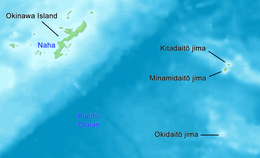
Minamidaitōjima (南大東島?), also spelt as Minami Daitō or Minami-Daitō, is the largest island in the Daitō Islands group southeast of Okinawa, Japan. It is administered as part of the village of Minamidaitō, Okinawa. Shimajiri District, Okinawa and has a population of 2,107. The island is entirely cultivated for agriculture, although it lacks freshwater sources. The island has no beaches or harbor, and cargo must be loaded/offloaded by crane; however the island has an airport Minami Daito Airport ( airport code "KTD").
Minamidaitōjima is a relatively isolated coralline island, located approximately 9 kilometres (4.9 nmi) south of Kitadaitōjima, the second largest island of the archipelago, and 360 kilometres (190 nmi) from Naha, Okinawa. As with the other islands in the archipelago, Minamidaitōjima is an uplifted coral atoll with a steep coastal cliff of limestone (the former fringing coral reef of the island), and a depressed center (the former lagoon of the island). The island is roughly oval in shape, with a circumference of about 13.52 kilometres (8.40 mi), length of 4.85 kilometres (3.01 mi) and an area of 11.94 square kilometres (4.61 sq mi). The highest point is 74 metres (243 ft) above sea level.
Minamidaitōjima has a humid subtropical climate (Köppen climate classification Cfa) with very warm summers and mild winters. Precipitation is significant throughout the year; the wettest month is June and the driest month is February. The island is subject to frequent typhoons.
...
Wikipedia

