Typhoon Kujira (2009)
| Typhoon (JMA scale) | |
|---|---|
| Category 4 (Saffir–Simpson scale) | |

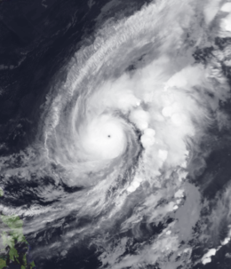
Typhoon Kujira near peak intensity
|
|
| Formed | May 1, 2009 |
| Dissipated | May 13, 2009 |
| (Extratropical after May 7, 2009) | |
| Highest winds |
10-minute sustained: 155 km/h (100 mph) 1-minute sustained: 215 km/h (135 mph) |
| Lowest pressure | 940 hPa (mbar); 27.76 inHg |
| Fatalities | 28 direct, 1 missing |
| Damage | At least $27 million (2009 USD) |
| Areas affected | Philippines, Russia |
| Part of the 2009 Pacific typhoon season | |
Typhoon Kujira, known in the Philippines as Typhoon Dante, was first reported by the Joint Typhoon Warning Center (JTWC) on April 28. It was the fourth depression and the first typhoon of the season. The disturbance dissipated later that day however it regenerated early on April 30 within the southern islands of Luzon. It was then designated as a Tropical Depression during the next morning by the Philippine Atmospheric, Geophysical and Astronomical Services Administration (PAGASA) and the Japan Meteorological Agency (JMA), with PAGASA assigning the name Dante to the depression. However the JTWC did not designate the system as a depression until early on May 2 which was after the depression had made landfall on the Philippines. Later that day Dante was upgraded to a Tropical Storm and was named as Kujira by the JMA. The cyclone started to rapidly intensify becoming a typhoon early on May 4, and then reaching its peak winds of 155 km/h (100 mph) (10-min), 215 km/h (135 mph) (1-min) later that day after a small clear eye had developed.
Torrential rains produced by Typhoon Kujira in the Bicol Peninsula triggered severe flooding and mudslides which killed 28 people and one missing.
On April 28, the Joint Typhoon Warning Center reported that an area of convection had persisted about 230 km (140 mi) to the northeast of Puerto Real in the Philippines. The disturbance had deep convection which was flaring in association with a mid level circulation center and was in an area of low vertical wind shear. However the disturbance then dissipated later that day. The disturbance then regenerated early on April 30, with a broad low level circulation center and was nestled within the islands of southern Luzon. An upper level anticyclone just to the northwest was enhancing pole ward outflow. During that day the disturbance developed further with improved convective banding in the northern quadrant, however interaction with land was a major hindrance. Early on May 1, the disturbance was designated as a Tropical Depression by the Philippine Atmospheric, Geophysical and Astronomical Services Administration (PAGASA) and the Japan Meteorological Agency, with PAGASA assigning the name Dante to the depression. Later that day PAGASA declared that Dante had made landfall on the Bicol Region in Southeastern Luzon. Early the next day the JTWC issued a Tropical Cyclone Formation Alert on the disturbance as whilst the low level circulation center had remained slow moving over southeastern Luzon the disturbance had a good outflow with convection starting to improve in terms of organization. Later that morning the JTWC designated the disturbance as Tropical Depression 01W. The Depression was being moved by the reverse oriented monsoon trough with a well formed low level circulation center with deep convective banding wrapping around the northern quadrant despite being close to land.
...
Wikipedia
