Tymovsky District
| Tymovsky District Тымовский район (Russian) |
|
|---|---|
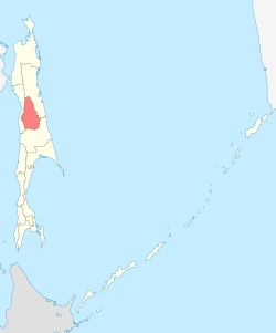
 Location of Tymovsky District in Sakhalin Oblast |
|
| Coordinates: 50°51′01″N 142°39′36″E / 50.85028°N 142.66000°ECoordinates: 50°51′01″N 142°39′36″E / 50.85028°N 142.66000°E | |
 Palevo Railway Station, Tymovsky District |
|
|
|
|
| Location | |
| Country | Russia |
| Federal subject | Sakhalin Oblast |
| Administrative structure (as of December 2011) | |
| Administrative center | urban-type settlement of Tymovskoye |
| Inhabited localities: | |
| Urban-type settlements | 1 |
| Rural localities | 24 |
| Municipal structure (as of July 2012) | |
| Municipally incorporated as | Tymovsky Urban Okrug |
| Statistics | |
| Area | 6,312.7 km2 (2,437.3 sq mi) |
| Population (2010 Census) | 16,212 inhabitants |
| • Urban | 48.5% |
| • Rural | 51.5% |
| Density | 2.57/km2 (6.7/sq mi) |
| Time zone | MAGT (UTC+11:00) |
| Official website | |
| on | |
Tymovsky District (Russian: Ты́мовский райо́н) is an administrative district (raion) of Sakhalin Oblast, Russia; one of the seventeen in the oblast.Municipally, it is incorporated as Tymovsky Urban Okrug. It is located in the center of the Island of Sakhalin. The area of the district is 6,312.7 square kilometers (2,437.3 sq mi). Its administrative center is the urban locality (an urban-type settlement) of Tymovskoye. Population: 16,212 (2010 Census);19,099 (2002 Census);25,774 (1989 Census). The population of Tymovskoye accounts for 48.5% of the district's total population.
The Tym River passes through the district in a roughly south-north direction.
...
Wikipedia

