Tunica County, Mississippi
| Tunica County, Mississippi | |
|---|---|
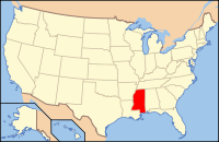
 Location in the U.S. state of Mississippi |
|
 Mississippi's location in the U.S. |
|
| Founded | 1836 |
| Named for | Tunica-Biloxi tribe |
| Seat | Tunica |
| Largest town | Tunica |
| Area | |
| • Total | 481 sq mi (1,246 km2) |
| • Land | 455 sq mi (1,178 km2) |
| • Water | 26 sq mi (67 km2), 5.4% |
| Population | |
| • (2010) | 10,778 |
| • Density | 24/sq mi (9/km²) |
| Congressional district | 2nd |
| Time zone | Central: UTC-6/-5 |
Tunica County is a county located in the U.S. state of Mississippi. As of the 2010 census, the population was 10,778. Its county seat is Tunica. The county is named for the Tunica Native Americans. Most migrated to central Louisiana during the colonial period.
Tunica County is part of the Memphis, TN–MS–AR Metropolitan Statistical Area. It is located in the Mississippi Delta region.
Since the late 20th century, it is known for Tunica Resorts (formerly Robinsonville), an unincorporated community that is the site of nine casino resorts. It is one of the top six destinations in the country in terms of gambling revenues.
According to the U.S. Census Bureau, the county has a total area of 481 square miles (1,250 km2), of which 455 square miles (1,180 km2) is land and 26 square miles (67 km2) (5.4%) is water.
As of the 2010 United States Census, there were 10,778 people residing in the county. 73.5% were Black or African American, 23.7% White, 0.6% Asian, 0.1% Native American, 0.1% Pacific Islander, 1.2% of some other race and 0.9% of two or more races. 2.3% were Hispanic or Latino (of any race).
...
Wikipedia
