Tuen Mun District
|
Tuen Mun 屯門區 |
||
|---|---|---|
| District | ||
| Tuen Mun District | ||

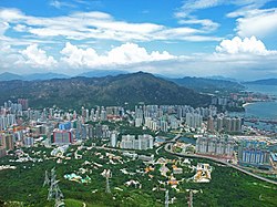
Day view of the Tuen Mun District skyline
|
||
|
||
 Location of Tuen Mun District within Hong Kong |
||
| Coordinates: 22°23′32″N 113°58′12″E / 22.39211°N 113.97011°ECoordinates: 22°23′32″N 113°58′12″E / 22.39211°N 113.97011°E | ||
| Country |
|
|
| Constituencies | 29 | |
| Government | ||
| • District Council Chairman | Leung Kin-man, BBS, MH, JP | |
| Area | ||
| • Total | 84.45 km2 (32.61 sq mi) | |
| Population (2006) | ||
| • Total | 502,035 | |
| • Density | 5,900/km2 (15,000/sq mi) | |
| Time zone | Hong Kong Time (UTC+8) | |
| Website | Tuen Mun District Council | |
| Tuen Mun District | |||||||||||||
| Traditional Chinese | 屯門區 | ||||||||||||
|---|---|---|---|---|---|---|---|---|---|---|---|---|---|
| Simplified Chinese | 屯门区 | ||||||||||||
|
|||||||||||||
| Transcriptions | |
|---|---|
| Standard Mandarin | |
| Hanyu Pinyin | Tún mén qū |
| Yue: Cantonese | |
| Yale Romanization | Tyùhn mùhn kēui |
| Jyutping | Tyun4 mun4 keoi1 |
Tuen Mun District (Chinese: 屯門區) is one of the 18 administrative districts of Hong Kong. Its name was previously 'Tsing Shan' and it changed in the 1970s. It is the westernmost continental district of Hong Kong, located about 32 km from the Kowloon Peninsula, 7 km southwest of Yuen Long and 18 km west of Tsuen Wan. It had a population of 488,831 in 2001. Part of the district is the Tuen Mun New Town, which contains one of the largest residential areas in the New Territories.
Originally named Castle Peak New Town when planning, the new town was finally named Tuen Mun, adopting the historic name of the region. The new town was built on reclaimed land from the Castle Peak Bay, starting from the late 1970s. The district was subsequently named Tuen Mun after its establishment in the early 1980s.
Tuen Mun Town Centre is the focal point of the district. It features a range of cultural and entertainment facilities and several government buildings, including Tuen Mun Town Plaza, Tuen Mun Cultural Square, Tuen Mun Town Hall, Tuen Mun Public Library, Tuen Mun Park, Tuen Mun Law Courts, Tuen Mun Central Post Office and Tuen Mun Government Offices.
Lung Kwu Tan Village has a history of a few hundred years. It is located at the southwest of Castle Peak and consists of Lung Kwu Tan and Lung Kwu Sheung Tan. It is said that Emperor Bing of Song went down the south as far as to Lung Kwu Tan when he fled from the invading Mongols. There is a cave at Lung Kwu Tan later known as the Emperor's Cave, which is presumably where Emperor Bing took refuge during his stay. Other famous spots include the Tin Hau Temple and the Bogy's Rock. While Lung Kwu Tan is place of primitive simplicity, the opening of privately run barbecue sites have always drawn crowds of holidaymakers.
...
Wikipedia

