Troup, Texas
| Troup, Texas | |
|---|---|
| City | |

Downtown Troup
|
|
| Motto: "The Good Neighbor Town" | |
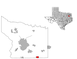
 Location of Troup, Texas |
|
 |
|
| Coordinates: 32°8′40″N 95°7′12″W / 32.14444°N 95.12000°WCoordinates: 32°8′40″N 95°7′12″W / 32.14444°N 95.12000°W | |
| Country | United States |
| State | Texas |
| Counties | Smith, Cherokee |
| Area | |
| • Total | 2.41 sq mi (6.24 km2) |
| • Land | 2.40 sq mi (6.22 km2) |
| • Water | 0.01 sq mi (0.03 km2) |
| Elevation | 456 ft (139 m) |
| Population (2010) | |
| • Total | 1,869 |
| • Density | 780/sq mi (300/km2) |
| Time zone | Central (CST) (UTC-6) |
| • Summer (DST) | CDT (UTC-5) |
| ZIP code | 75789 |
| Area code(s) | 903 |
| FIPS code | 48-73724 |
| GNIS feature ID | 1348809 |
| Website | www |
Troup is a city in Smith and Cherokee counties in the U.S. state of Texas. The population was 1,869 at the 2010 census. Troup lies in two counties as well as two core based statistical areas. The Smith County portion of the city is part of the Tyler Metropolitan Statistical Area, while the Cherokee County portion is part of the Jacksonville Micropolitan Statistical Area.
Troup is situated between the two very old Choctaw, Chickasaw, and Creek intertribal settlements of Nanih Shinuk (Sand Hill) and Ofunlo Hina (Screech Owl Bend), whose descendants still live there.
Troup was developed as a railroad town when the International Railroad Company opened the Palestine-Troupe line in 1872. The town was platted in 1873.
The town may have been named after a governor or a county in Georgia.
Troup is located in southeastern Smith County at 32°8′40″N 95°7′12″W / 32.14444°N 95.12000°W (32.144382, -95.120018). The city limits extend south into Cherokee County. Texas State Highway 110 passes through the center of town, leading northwest 19 miles (31 km) to Tyler and south 26 miles (42 km) to Rusk. Texas State Highway 135 shares two blocks of Duval Street (Named after John Crittendon Duval the only survivor of the Goliad Massacre,and known as the Father of Texas Literature)with Highway 110 in the center of town and leads northeast 25 miles (40 km) to Kilgore and southwest 17 miles (27 km) to Jacksonville.
...
Wikipedia
