Tropical Storm Etau (2009)
| Tropical storm (JMA scale) | |
|---|---|
| Tropical storm (Saffir–Simpson scale) | |

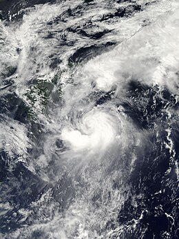
Tropical Storm Etau at peak intensity on August 10
|
|
| Formed | August 8, 2009 |
| Dissipated | August 16, 2009 |
| (Extratropical after August 14, 2009) | |
| Highest winds |
10-minute sustained: 75 km/h (45 mph) 1-minute sustained: 75 km/h (45 mph) |
| Lowest pressure | 992 hPa (mbar); 29.29 inHg |
| Fatalities | 28 total |
| Damage | $87.5 million (2009 USD) |
| Areas affected | Japan (particularly Hyōgo Prefecture) |
| Part of the 2009 Pacific typhoon season | |
Tropical Storm Etau was the deadliest tropical cyclone to impact Japan since Typhoon Tokage in 2004. Forming on August 8, 2009 from an area of low pressure, the system gradually intensified into a tropical storm. Tracking in a curved path around the edge of a subtropical ridge, Etau continued to intensify as it neared Japan. By August 10, the cyclone reached its peak intensity as a weak tropical storm with winds of 75 km/h (45 mph 10-minute sustained) and a barometric pressure of 992 hPa (mbar). Shortly after, Etau began to weaken. Increasing wind shear led to the center becoming devoid of convection and the system eventually weakened to a tropical depression on August 13. The remnants of Etau persisted for nearly three days before dissipating early on August 16.
Although Etau did not make landfall, the outer bands of the storm produced torrential rainfall in Japan, peaking at 326.5 mm (12.85 in). These rains triggered deadly flooding and mudslides, especially in Hyōgo Prefecture. Twenty-eight people were killed by the storm and ¥7.1 billion (US$87.5 million) in damage occurred throughout the affected region. According to the Fire and Disaster Management Agency, a total of 5,602 homes were flooded and 183 were destroyed. Following the storm, 600 Japanese soldiers were deployed from Tokyo to assist in cleanup efforts.
Tropical Storm Etau originated on August 5 out of an area of low pressure associated with disorganized convective activity located about 550 km (280 mi) east-northeast of Guam. The following day, the system relocated several dozen kilometers to the north. Convective turning began to appear on satellite imagery and a Tropical Upper Tropospheric Trough (TUTT) cell to the north provided a northward component to the system's movement. Early on August 7, the Joint Typhoon Warning Center (JTWC) issued a Tropical Cyclone Formation Alert for the developing system as deep convection consolidated around the low pressure system. Around 0000 UTC on August 8, the Japan Meteorological Agency (JMA) designated the system as a tropical depression.
...
Wikipedia
