Tropical Storm Barry (2007)
| Tropical storm (SSHWS/NWS) | |

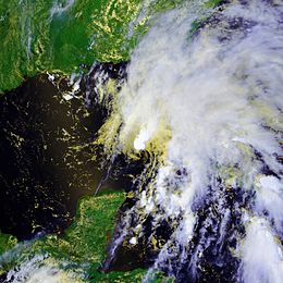
Tropical Storm Barry shortly after being classified
|
|
| Formed | June 1, 2007 |
|---|---|
| Dissipated | June 5, 2007 |
| (Extratropical after June 2, 2007) | |
| Highest winds |
1-minute sustained: 60 mph (95 km/h) |
| Lowest pressure | 997 mbar (hPa); 29.44 inHg |
| Fatalities | 1 direct, 2 indirect |
| Damage | $118,000 (2007 USD) |
| Areas affected | El Salvador, western Cuba, Florida, East Coast of the United States |
| Part of the 2007 Atlantic hurricane season | |
Tropical Storm Barry was a rapidly forming tropical cyclone that made landfall on Florida, United States, in early June 2007. The second named storm of the 2007 Atlantic hurricane season, Barry developed from a trough of low pressure in the southeastern Gulf of Mexico on June 1. It tracked rapidly northeastward, reaching peak winds of 60 mph (95 km/h) before weakening and making landfall near Tampa Bay as a tropical depression. Barry quickly lost tropical characteristics after wind shear removed much of the convection, and early on June 3 it completed the transition into an extratropical cyclone. The extratropical remnants tracked up the East Coast of the United States, and were absorbed by a larger extratropical cyclone on June 5.
The precursor trough produced heavy rainfall across the western Caribbean Sea, which on Cuba unofficially reached over 7.8 inches (200 mm). Outer rainbands in Pinar del Río Province injured three people and damaged 55 houses. In Florida, Barry dropped a moderate amount of precipitation across the drought-ridden state; rainfall peaked at 6.99 inches (178 mm). The rain caused some flooding and wet roads, which led to two indirect traffic fatalities. Rough seas killed one Florida surfer in Pinellas County. In Florida and Georgia, the precipitation assisted firefighters in combating severe wildfires. Overall damage from the storm was minor.
...
Wikipedia
