Triefenstein
| Triefenstein | ||
|---|---|---|

Kloster Triefenstein seen from Lengfurt
|
||
|
||
| Coordinates: 49°48′N 9°36′E / 49.800°N 9.600°ECoordinates: 49°48′N 9°36′E / 49.800°N 9.600°E | ||
| Country | Germany | |
| State | Bavaria | |
| Admin. region | Unterfranken | |
| District | Main-Spessart | |
| Government | ||
| • Mayor | Norbert Endres (CSU) | |
| Area | ||
| • Total | 25.47 km2 (9.83 sq mi) | |
| Elevation | 140-296 m (−831 ft) | |
| Population (2015-12-31) | ||
| • Total | 4,332 | |
| • Density | 170/km2 (440/sq mi) | |
| Time zone | CET/CEST (UTC+1/+2) | |
| Postal codes | 97855 | |
| Dialling codes | 09395 | |
| Vehicle registration | MSP | |
| Website | www.markt-triefenstein.de | |
Markt Triefenstein is a market community in the Main-Spessart district in the Regierungsbezirk of Lower Franconia (Unterfranken) in Bavaria, Germany. It was created in 1978 out of the villages Homburg am Main, Lengfurt, Rettersheim and Trennfeld.
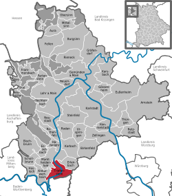
Markt Triefenstein is part of the Main-Spessart district of Bavaria. It is located on the river Main between Marktheidenfeld and Wertheim am Main. To the south it borders on Baden-Württemberg.
The community has the following Gemarkungen (traditional rural cadastral areas): Homburg am Main, Lengfurt, Rettersheim and Trennfeld. The former two are located on the left bank of the Main, the latter two on the right bank.
The hills in the east of the community's territory are made up of Muschelkalk on top of the normal Buntsandstein or red sandstone of the Spessart hills. This terroir makes the area around Homburg well-suited for growing wine. In addition, the vineyards profit from the protective bowl-shape of the hill (Kallmuth, 278 metres above sea level) and the heat-store of the river Main. Since 1981, the vineyards on Kallmuth have been a protected monument. The Bocksberg, west of the Main, is the western-most muschelkalk occurrence in Bavaria.
Homburg castle sits on a rock made up of tufa.
A burial site near Trennfeld is attributed to the urnfield culture (1200 to 750 BC) and nearby there is a group of 15 burial mounds from the Iron Age (700 to 450 BC).
Archeological evidence points to Iron Age fortifications on a rocky outcropping on the right bank of the Main, north of where the monastery stands today. Later this was the site of early medieval fortifications and then of the Neuenburg castle (12th or 13th century), associated with the Ravensburg family and which was likely destroyed in a fire. The site was strategically important, controlling the Via Publica, dating back to Roman times, and its Main crossing at Lengfurt.
...
Wikipedia


