Travis County, Texas
| Travis County, Texas | ||
|---|---|---|

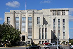
Heman Marion Sweatt Travis County Courthouse in Austin
|
||
|
||
 Location in the U.S. state of Texas |
||
 Texas's location in the U.S. |
||
| Founded | 1840 | |
| Named for | William B. Travis | |
| Seat | Austin | |
| Largest city | Austin | |
| Area | ||
| • Total | 1,023 sq mi (2,650 km2) | |
| • Land | 990 sq mi (2,564 km2) | |
| • Water | 33 sq mi (85 km2), 3.2% | |
| Population (est.) | ||
| • (2014) | 1,151,145 | |
| • Density | 1,163/sq mi (449/km²) | |
| Congressional districts | 10th, 17th, 21st, 25th, 35th | |
| Time zone | Central: UTC-6/-5 | |
| Website | traviscountytx |
|
Coordinates: 30.33°0′N 97.78°0′W / 30.330°N 97.780°W
Travis County is a county located in south central Texas. As of the 2010 census, the population was 1,024,266; the estimated population in 2014 was 1,151,145. It is the fifth-most populous county in Texas. Its county seat is Austin, the capital of Texas. The county was established in 1840 and is named in honor of William Barret Travis, the commander of the Republic of Texas forces at the Battle of the Alamo.
Travis County is part of the Austin-Round Rock Metropolitan Statistical Area. It is located along the Balcones Fault, the boundary between the Edwards Plateau to the west and the Blackland Prairie to the east.
Evidence of habitation of the Balcones Escarpment region of Texas can be traced to at least 11,000 years ago. Two of the oldest Paleolithic archeological sites in Texas, the Levi Rock Shelter and Smith Rock Shelter, are located in southwest and southeast Travis County, respectively. Several hundred years before the arrival of European settlers, the area was inhabited by a variety of nomadic Native American tribes. These indigenous peoples fished and hunted along the creeks, including present-day Barton Springs, which proved to be a reliable campsite. At the time of the first permanent settlement of the area, the Tonkawa tribe was the most common, with the Comanches and Lipan Apaches also frequenting the area.
...
Wikipedia

