Trail magic
| Appalachian Trail | |
|---|---|

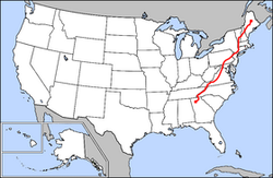
Map of Appalachian Trail
|
|
| Length | About 2,200 miles (3,500 km) |
| Location | Appalachian Mountains |
| Designation | National Scenic Trail |
| Trailheads |
Springer Mountain, Georgia Mount Katahdin, Maine |
| Use | Hiking |
| Elevation | |
| Highest point | Clingmans Dome, 6,643 ft (2,025 m) |
| Lowest point | Bear Mountain State Park, 124 ft (38 m) |
| Hiking details | |
| Trail difficulty | Easy to strenuous |
| Season | Early spring to autumn |
| Sights | Appalachian Mountains |
| Hazards |
Severe weather American black bear Tick-borne diseases Mosquitos Yellowjackets Biting flies Chiggers Steep grades Limited water Dangerous Fordings Diarrhea from water Poison ivy Venomous snake |
| Website | Appalachian Trail |
The Appalachian National Scenic Trail, generally known as the Appalachian Trail or simply the A.T., is a marked hiking trail in the Eastern United States extending between Springer Mountain in Georgia and Mount Katahdin in Maine. The trail is about 2,200 miles (3,500 km) long, though the exact length changes over time as parts are modified or rerouted. The Appalachian Trail Conservancy claims that the Appalachian Trail is the longest hiking-only trail in the world. More than 2 million people are said to do at least one day-hike on the trail each year.
The idea of the Appalachian Trail came about in 1921. The trail itself was completed in 1937 after more than a decade of work, although improvements and changes continue. It is maintained by 31 trail clubs and multiple partnerships, and managed by the National Park Service, United States Forest Service, and the nonprofit Appalachian Trail Conservancy. The majority of the trail is in forest or wild lands, although some portions traverse towns, roads and farms. It passes through 14 states: Georgia, North Carolina, Tennessee, Virginia, West Virginia, Maryland, Pennsylvania, New Jersey, New York, Connecticut, Massachusetts, Vermont, New Hampshire, and Maine.
...
Wikipedia
