Totoket, Connecticut
| North Branford, Connecticut | ||
|---|---|---|
| Town | ||
|
Totoket Mountain, the high point at 720 feet in North Branford, CT.
|
||
|
||
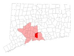
 Location in New Haven County, Connecticut |
||
| Coordinates: 41°21′25″N 72°46′05″W / 41.35694°N 72.76806°WCoordinates: 41°21′25″N 72°46′05″W / 41.35694°N 72.76806°W | ||
| Country | United States | |
| State | Connecticut | |
| NECTA | New Haven | |
| Region | South Central Region | |
| Incorporated | 1831 | |
| Government | ||
| • Type | Council-manager | |
| • Town manager | Richard V. Branigan | |
| • Town council | Anthony Candelora (R), Mayor Joanne S. Wentworth (R), Deputy Mayor Daniel M. Armin (D) Marie E. Diamond (D) Vincent Caprio (R) Andrew Esposito III (D) Joseph Faughnan (D) Donald J. Fucci II (R) Alfred Rose (R) |
|
| Area | ||
| • Total | 26.7 sq mi (69.2 km2) | |
| • Land | 24.9 sq mi (64.5 km2) | |
| • Water | 1.7 sq mi (4.5 km2) | |
| Elevation | 207 ft (63 m) | |
| Population (2010) | ||
| • Total | 14,407 | |
| • Density | 540/sq mi (210/km2) | |
| Time zone | Eastern (UTC-5) | |
| • Summer (DST) | Eastern (UTC-4) | |
| ZIP code | 06471, 06472 | |
| Area code(s) | 203 | |
| FIPS code | 09-53890 | |
| GNIS feature ID | 0213477 | |
| Website | www |
|
North Branford is a town in New Haven County, Connecticut, United States. The population was 14,407 at the 2010 census.
The town has the neighborhoods of Totoket, Wood Chase, Northford, Sea Hill, Twin Lakes, ENB, South Queach, Ashley Park, and Doral Farms.
This early mill and farming community incorporated from Branford in 1831. The year prior, Maltby Fowler had opened a button-making shop. Its success along with the inventiveness of his six sons—who devised a range of machines to produce such things as screws, embossed silk, pins, and horseshoe nails—saw the rise of new manufactories along the town’s Farm River. By the early 1900s, North Branford’s abundant supply of trap rock, a material used for making roadways, made quarrying a growth industry. Today, the town’s manufacturing sector is concentrated in electronics and electronic components.
According to the United States Census Bureau, the town has a total area of 26.6 square miles (69.0 km²), of which 24.9 square miles (64.5 km²) is land and 1.7 square miles (4.5 km²) (6.49%) is water. Neighboring towns are Wallingford and Durham to the north, Guilford to the east, Branford to the south, and North Haven and East Haven to the west.
Much of the town's acreage is dominated by Totoket Mountain, part of the Metacomet Ridge, a mountainous trap rock ridgeline that stretches from Long Island Sound almost to the Vermont border. The north side of Saltonstall Mountain is also located in North Branford. Totoket Mountain contains Lake Gaillard, a reservoir, formed in 1926, managed by the South Central Connecticut Regional Water Authority (SCCRWA). The SCCRWA maintains a network of hiking trails on Totoket Mountain in the Big Gulph area of Northford. The SCCRWA is said to own one-third of the town's area.
...
Wikipedia

