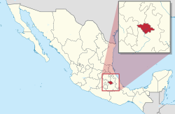
Tlaxcala (state)
| Tlaxcala | ||
|---|---|---|
| State | ||
| Estado Libre y Soberano de Tlaxcala | ||
|
||
| Motto: Cuna de la Nación (Cradle of the Nation) | ||
| Anthem: Himno a Tlaxcala | ||
 State of Tlaxcala within Mexico |
||
| Coordinates: 19°26′N 98°10′W / 19.433°N 98.167°WCoordinates: 19°26′N 98°10′W / 19.433°N 98.167°W | ||
| Country | Mexico | |
| Capital | Tlaxcala de Xicohténcatl | |
| Largest City | Tlaxcala de Xicohténcatl | |
| Municipalities | 60 | |
| Admission | December 9, 1856 | |
| Order | 22nd | |
| Government | ||
| • Governor |
Marco Mena |
|
| • Senators |
|
|
| • Deputies | ||
| Area | ||
| • Total | 4,016 km2 (1,551 sq mi) | |
| Highest elevation | 4,420 m (14,500 ft) | |
| Population (2015) | ||
| • Total | 1,272,847 | |
| • Rank | 28th | |
| • Density | 320/km2 (820/sq mi) | |
| • Density rank | 3rd | |
| Demonym(s) | Tlaxcalteca | |
| Time zone | CST (UTC−6) | |
| • Summer (DST) | CDT (UTC−5) | |
| Postal code | 90 | |
| Area code | ||
| ISO 3166 code | MX-TLA | |
| HDI |
|
|
| GDP | US$ 3.601 Billion | |
| Website | Official Web Site | |
| ^ a. The state's GDP was 46,094,141 thousand of pesos in 2008, amount corresponding to 3,601,104.7 thousand of dollars, being a dollar worth 12.80 pesos (value of June 3, 2010). | ||
 Apizaco |
Num. | City | Municipality | Pop. | Num. | City | Municipality | Pop. |
 Zacatelco |
|---|---|---|---|---|---|---|---|---|---|
| 1 | Vicente Guerrero | San Pablo del Monte Municipality | 60 001 | 8 | Papalotla | Papalotla de Xicohténcatl Municipality | 22 969 | ||
| 2 | Huamantla | Huamantla Municipality | 51 996 | 9 | Ocotlán | Tlaxcala Municipality | 22 248 | ||
| 3 | Apizaco | Apizaco Municipality | 49 506 | 10 | La Magdalena Tlaltelulco | La Magdalena Tlaltelulco Municipality | 16 834 | ||
| 4 | Chiautempan | Chiautempan Municipality | 48 030 | 11 | Teolocholco | Teolocholco Municipality | 16 240 | ||
| 5 | Zacatelco | Zacatelco Municipality | 38 466 | 12 | Tetla | Tetla Municipality | 15 161 | ||
| 6 | Calpulalpan | Calpulalpan Municipality | 33 263 | 13 | Tlaxco | Tlaxco Municipality | 14 806 | ||
| 7 | Contla | Contla Municipality | 27 610 | 14 | Tlaxcala | Tlaxcala Municipality | 14 692 |
Tlaxcala (Spanish ![]() [tla(k)sˈkala] ; /tlɑːsˈkɑːlə/; [tla(ɣ)sˈkala]; from Nahuatl: Tlaxcallān Nahuatl pronunciation: [tɬaʃˈkalːaːn]), officially the Free and Sovereign State of Tlaxcala (Spanish: Estado Libre y Soberano de Tlaxcala), is one of the 31 states which along with the Federal District make up the 32 federative entities of Mexico. It is divided into 60 municipalities and its capital city is Tlaxcala.
[tla(k)sˈkala] ; /tlɑːsˈkɑːlə/; [tla(ɣ)sˈkala]; from Nahuatl: Tlaxcallān Nahuatl pronunciation: [tɬaʃˈkalːaːn]), officially the Free and Sovereign State of Tlaxcala (Spanish: Estado Libre y Soberano de Tlaxcala), is one of the 31 states which along with the Federal District make up the 32 federative entities of Mexico. It is divided into 60 municipalities and its capital city is Tlaxcala.
It is located in East-Central Mexico, in the altiplano region, with the eastern portion dominated by the Sierra Madre Oriental. It is bordered by the states of Puebla to the north, east and south, México to the west and Hidalgo to the northwest. It is the smallest state of the republic, accounting for only 0.2% of the country’s territory.
...
Wikipedia


