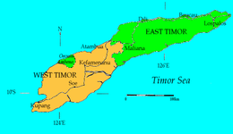
Timor Island

Political division of Timor
|
|
| Geography | |
|---|---|
| Location | South East Asia |
| Coordinates | 9°14′S 124°56′E / 9.233°S 124.933°ECoordinates: 9°14′S 124°56′E / 9.233°S 124.933°E |
| Area | 30,777 km2 (11,883 sq mi) |
| Area rank | 44th |
| Highest elevation | 9,720 ft (2,963 m) |
| Highest point | Ramelau |
| Administration | |
|
East Timor
|
|
| Largest settlement | Dili (pop. 193,563 as of 2010[update]) |
|
Indonesia
|
|
| Province | East Nusa Tenggara |
| Largest settlement | Kupang (West Timor) (pop. 349,344 as of 2011[update]) |
| Demographics | |
| Population | 3,182,693 (2014) |
| Pop. density | 94.5 /km2 (244.8 /sq mi) |
Timor is an island at the southern end of Maritime Southeast Asia, north of the Timor Sea. The island is divided between the sovereign states of East Timor, on the eastern part, and Indonesia, on the western part. The Indonesian part, also known as West Timor, constitutes part of the province of East Nusa Tenggara. Within West Timor lies an exclave of East Timor called Oecusse District. The island covers an area of 30,777 square kilometres (11,883 square miles). The name is a variant of timur, Malay for "east"; it is so called because it lies at the eastern end of the Lesser Sunda Islands.
Anthropologists identify eleven distinct ethno-linguistic groups in Timor. The largest are the Atoni of western Timor, and the Tetum of central and eastern Timor. Most indigenous Timorese languages belong to the Timor–Babar branch of the Austronesian languages spoken throughout the Indonesian archipelago. The non-Austronesian languages are thought to be related to languages spoken on Halmahera and in Western New Guinea. Some are so mixed it is difficult to tell which family they descend from.
The official languages of East Timor are Tetum and Portuguese, while in West Timor it is Indonesian. Indonesian is also widely spoken and understood in East Timor.
...
Wikipedia

